IMAGES TAKEN NEAR TO
Portland Street South, ASHTON-UNDER-LYNE, OL6 7UE
Introduction
This page details the photographs taken nearby to Portland Street South, OL6 7UE by members of the Geograph project.
The Geograph project started in 2005 with the aim of publishing, organising and preserving representative images for every square kilometre of Great Britain, Ireland and the Isle of Man.

There are currently over 7.5m images from over14,400 individuals and you can help contribute to the project by visiting https://www.geograph.org.uk
Image Map (Loading...)


Getting Data...Please wait
Leaflet Map data © OpenStreetMap
Images are licensed for reuse under creativecommons.org/licenses/by-sa/2.0
Notes
- Clicking on the map will re-center to the selected point.
- The higher the marker number, the further away the image location is from the centre of the postcode.
Image Listing (540 Images Found)
Images are licensed for reuse under creativecommons.org/licenses/by-sa/2.0
Image
Details
Distance
1
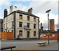
Friendship Inn
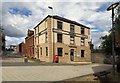
In the middle of the St Petersfield development (proclaimed as Ashton's new urban business quarter) stands the Friendship Inn. It's been friendless for more than four years Image It was built in 1827 by Thomas Schofield and it was the home of the Schofield brewery until it was absorbed by Robinson's.
Image: © Gerald England
Taken: 24 Feb 2012
0.01 miles
2
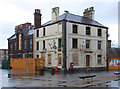
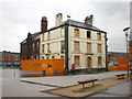
The end of a Friendship?
4 years after Alexander Kapp's view http://www.geograph.org.uk/photo/1289039 the building looks even more derelict. At least the roof remains intact for the time being.
Image: © Alan Murray-Rust
Taken: 7 Jan 2014
0.01 miles
3
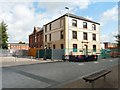
Former Friendship Inn
Image: © Gerald England
Taken: 4 Aug 2014
0.01 miles
4
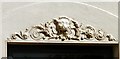
Friendship Inn: Architectural Detail
Detail of frieze above the windows of the Friendship Inn Image
Image: © Gerald England
Taken: 4 Aug 2014
0.01 miles
5
Former Friendship Inn
In the middle of the St Petersfield development (proclaimed as Ashton's new urban business quarter) stood the Friendship Inn. It was built in 1827 by Thomas Schofield and was the home of the Schofield brewery until it was absorbed by Robinson's. It closed around 2008 and was derelict for several years but it has now been restored and is offices belonging to Pearson, solicitors and financial advisers.
Image: © Gerald England
Taken: 16 Sep 2017
0.01 miles
6
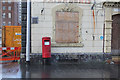
Postbox at Henry Square outside the Friendship, ref OL6 30
The later style of EIIR pillar box.
Image: © Alan Murray-Rust
Taken: 7 Jan 2014
0.01 miles
7
Friendship
The sign says "Closed for refurbishment open Spring 2008", something has gone wrong its now Spring 2009
Image: © Alexander P Kapp
Taken: 5 May 2009
0.01 miles
9
St Petersfield
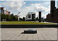
The west end of Ashton has been undergoing transformation since 2009. Most of Old Street and Henry Square have been bulldozed. In the foreground is a plaque to Henry Vollam Morton Image now just set in stone. On the left is the new Tameside Magistrates Court Image On the right is the old Swimming Baths Image which has survived due to its Grade II listing. In the background is a new office block whose tenants include the local Primary Care Health Trust.
Image: © Gerald England
Taken: 4 Aug 2014
0.03 miles
10
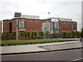
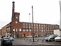
Tameside Magistrates and County Courts
Image: © Alexander P Kapp
Taken: 5 May 2009
0.03 miles