IMAGES TAKEN NEAR TO
Brookdale Avenue, ASHTON-UNDER-LYNE, OL6 7UD
Introduction
This page details the photographs taken nearby to Brookdale Avenue, OL6 7UD by members of the Geograph project.
The Geograph project started in 2005 with the aim of publishing, organising and preserving representative images for every square kilometre of Great Britain, Ireland and the Isle of Man.

There are currently over 7.5m images from over14,400 individuals and you can help contribute to the project by visiting https://www.geograph.org.uk
Image Map (Loading...)


Getting Data...Please wait
Leaflet Map data © OpenStreetMap
Images are licensed for reuse under creativecommons.org/licenses/by-sa/2.0
Notes
- Clicking on the map will re-center to the selected point.
- The higher the marker number, the further away the image location is from the centre of the postcode.
Image Listing (401 Images Found)
Images are licensed for reuse under creativecommons.org/licenses/by-sa/2.0
Image
Details
Distance
1
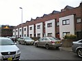
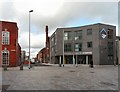
Chambers Mews
New housing on Bentinck Street.
Image: © Gerald England
Taken: 18 Dec 2014
0.02 miles
2
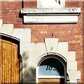
Egret Mill Company MDCCCLXIV
Detail around the door of the former Egret Mill offices Image
Image: © Gerald England
Taken: 4 Aug 2014
0.03 miles
3
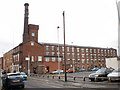
Network Connect Limited / Egret Mill
Network Connect is a voice and data communication
technology company http://www.networkconnect.co.uk/
They are based in the former office block of Egret Mill on Old Street - built in 1864, the oldest part of a mill complex that dated from 1823. An adjoining 5-storey spinning block was destroyed by fire in 1881 and replaced by weaving sheds, the last part of which were demolished in 2013. http://www.ashton-under-lyne.com/history/cotton.htm
For a photograph from 1910 see http://ashton-under-lyne.blogspot.co.uk/2010/05/monochrome-moment-egret-mill.html
Doorway detail: Image
Image: © Gerald England
Taken: 4 Aug 2014
0.03 miles
6
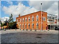
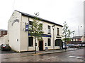
Tameside Centre for Enterprise
In a new building at the corner of Old Street and Bentinck Street in the St Petersfield development is the Tameside Centre for Enterprise which according to its website http://www.tcfe.co.uk/ has been established to create new businesses and support existing businesses in Greater Manchester. "The Centre offers incubation space and support for people starting new businesses, accelerator programmes for growing businesses and conference facilities including meeting rooms. Through practical support and flexible development space, our mission is to create a new generation of entrepreneurs and promote business growth."
Image: © Gerald England
Taken: 24 Feb 2012
0.04 miles
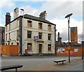
7

The Witchwood
A popular music venue on Old Street. It lies on the edge of the St Petersfield development and (unlike the Friendship Image) was threatened with a CPO and demolition. It fought to be retained and was successful.
The pub was known in 1850 as the Painters Arms and was a meeting place for local masons. It was sold to Oldham Brewery in 1897. Between 1886 and 1893 it was called the Rifle Brigade before reverting to the Painters Arms. In 1897 to became the Globe Inn. In 1985 it became one of the "Fighting Cock" group of free houses and renamed the Gamecock. In 1988 it was bought by John Dyson who renamed it the Witchwood.
Image: © Gerald England
Taken: 24 Feb 2012
0.05 miles
8
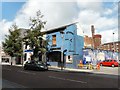
The Witchwood
The Witchwood is a public house and has been a hub for live indie and rock music since the 1960s.
In 2004, Tameside Metropolitan Borough Council served a compulsory purchase order on The Witchwood as plans for the regeneration of the surrounding area required the building to be removed. After a campaign to save The Witchwood, supported by regular customers, local amateur musicians, businesses and live venues, live music fans from across the country, Ask Developments – the company regenerating the surrounding area – agreed that The Witchwood would not be demolished on condition that "the exterior would be re-rendered and new windows put in".
Witchwood website: http://www.thewitchwood.net/
Image: © Gerald England
Taken: 4 Aug 2014
0.05 miles
9
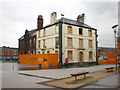
Friendship
The sign says "Closed for refurbishment open Spring 2008", something has gone wrong its now Spring 2009
Image: © Alexander P Kapp
Taken: 5 May 2009
0.05 miles
10
Friendship Inn
In the middle of the St Petersfield development (proclaimed as Ashton's new urban business quarter) stands the Friendship Inn. It's been friendless for more than four years Image It was built in 1827 by Thomas Schofield and it was the home of the Schofield brewery until it was absorbed by Robinson's.
Image: © Gerald England
Taken: 24 Feb 2012
0.05 miles