IMAGES TAKEN NEAR TO
Church Street, ASHTON-UNDER-LYNE, OL6 7PR
Introduction
This page details the photographs taken nearby to Church Street, OL6 7PR by members of the Geograph project.
The Geograph project started in 2005 with the aim of publishing, organising and preserving representative images for every square kilometre of Great Britain, Ireland and the Isle of Man.

There are currently over 7.5m images from over14,400 individuals and you can help contribute to the project by visiting https://www.geograph.org.uk
Image Map
Images are licensed for reuse under creativecommons.org/licenses/by-sa/2.0
Notes
- Clicking on the map will re-center to the selected point.
- The higher the marker number, the further away the image location is from the centre of the postcode.
Image Listing (576 Images Found)
Images are licensed for reuse under creativecommons.org/licenses/by-sa/2.0
Image
Details
Distance
1
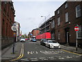
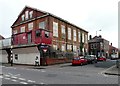
Warrington Street, Ashton under Lyne (1)
Image: © Richard Vince
Taken: 12 May 2018
0.01 miles
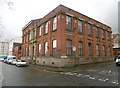
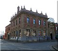
2
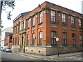
Former Ashton under Lyne Mechanics' Institution
On the corner of Warrington Street (right) and Church Street.
Image: © Richard Vince
Taken: 12 May 2018
0.01 miles
3
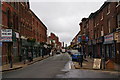
Stamford Street, Ashton-under-Lyne
This used to be the most prestigious street, but the focus of the town has shifted to the north, and you can see it is past its best. The old baths and St Peter's Church are visible, as intended when the streets were laid out.
Image: © Bill Boaden
Taken: 29 Sep 2009
0.01 miles
4
Ashton-under-Lyne, Mechanics' Institute
On Church Street/Warrington Street; former institute, dated 1862, later school.
Image: © Mike Faherty
Taken: 8 Feb 2019
0.02 miles
5
Former Methodist Church
Work to convert the former Stamford Street Methodist Church into apartments started a few years ago but came to a halt. It has been left in limbo for so long that the ivy on the side walls is now claiming the boarding over the windows.
Image: © Gerald England
Taken: 24 Oct 2012
0.02 miles
6
The Station, Warrington Street, Ashton-under-Lyne
This was a former railway station, but all signs have disappeared apart from the signal in the garden. It is now a very acceptable pub.
Image: © Bill Boaden
Taken: 29 Sep 2009
0.02 miles
7
179 Stamford Street Central
Former National Westminster bank. Now home to Rysy Skelp European Food Off-Licence.
Image: © Gerald England
Taken: 13 Feb 2023
0.02 miles
8
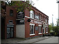
The Station pub, Warrington Street, Ashton under Lyne
Now separated from the site of the long closed Ashton Park Parade station (on the line between Stalybridge and Guide Bridge) by the A635.
Image: © Richard Vince
Taken: 12 May 2018
0.02 miles
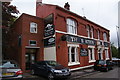
9

Ashton-under-Lyne, Station Hotel
Public house off Church Street, so called because it once served Park Parade Station. Three rooms, counter left, drinking areas left and back. High ceilings, large wooden counter back, wooden fireplace surround, eclectic display of cases and railway memorabilia, garden with railway signals - and a friendly dog. One room serves as distribution point for food bags for local homeless. Cask ales on offer: Adnam's Broadside, Three Bees Bees' Knees.
Image: © Mike Faherty
Taken: 8 Feb 2019
0.03 miles
10
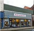
Wooden Canal Boat Society Shop
Charity shop for the Wooden Canal Boat Society http://wcbs.org.uk/
Image: © Gerald England
Taken: 23 Jan 2016
0.03 miles