
IMAGES TAKEN NEAR TO
Grey Street, ASHTON-UNDER-LYNE, OL6 6XF
Introduction
This page details the photographs taken nearby to Grey Street, OL6 6XF by members of the Geograph project.
The Geograph project started in 2005 with the aim of publishing, organising and preserving representative images for every square kilometre of Great Britain, Ireland and the Isle of Man.

There are currently over 7.5m images from over14,400 individuals and you can help contribute to the project by visiting https://www.geograph.org.uk
Image Map
Images are licensed for reuse under creativecommons.org/licenses/by-sa/2.0
Notes
- Clicking on the map will re-center to the selected point.
- The higher the marker number, the further away the image location is from the centre of the postcode.
Image Listing (539 Images Found)
Images are licensed for reuse under creativecommons.org/licenses/by-sa/2.0
Image
Details
Distance
5
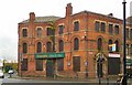
Former Yate's Wine Lodge
A building on Old Square at the corner of Grey Street and Stamford Street was recorded in 1784 as the Wheatsheaf but was renamed in 1786 as the Buck & Breeches. It became the Wheatsheaf again in 1803 but by 1816 had become the Hare & Hounds but by 1822 was again the Wheatsheaf. It was rebuilt in 1879 and incorporated the Golden Lion next door. It was sold to William Yates in 1896. It was a Yates' till 1998 when it became Doctor Browns, a moniker it bore till around 2006 when it became Legends. By 2008, it was destroyed by fire.
Image: © Gerald England
Taken: 31 Oct 2011
0.03 miles
6
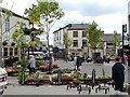
Market St
Looking down past Bow St and George St
Image: © Ian Yates
Taken: 22 Jun 2002
0.03 miles
7
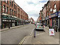
Stamford Street Central
Looking, from Old Square, down Stamford Street .
Looking at this photo, taken on a busy Saturday afternoon when the market and the Ladysmith precinct were packed, it is hard to believe that Stamford Street was once a thriving shopping street at the heart of Ashton. Walking down here in the 1950s, one could hardly walk on the pavement because so many people were shopping all the way down both sides of the street with its mixture of high-end specialist shops down to the small independents as well as the national high street chain stores together with further shops in the adjoining arcades.
The decline of Stamford Street began in the 1960s when the town centre by-pass (Park Parade) was built to the south of the town. Instead of doing similar to the north and east of the town, Oldham Road was widened and cut through the middle of Stamford Street to join the by-pass.
The decline of Stamford Street was further exacerbated with the building of the new precinct causing Stamford Street to lose its big-name shops (Woolworths, Littlewoods, Timothy Whites/Boots etc) leaving it in a sorry state by the early 1970s. Nowadays, only by looking at the Victorian facades high above the modern shop fronts do you get a glimpse of its past glories. I think that the furnishing shop on the left might have been Woolworth's in the 1950s).
Maybe Stamford Street would have declined anyway, like many of the High Streets around the country as smaller independent retailers struggle to compete, but the planning decisions taken in the 1960s certainly hastened the decline and left this area of Ashton a mess for decades.
Image: © David Dixon
Taken: 4 Jun 2011
0.03 miles
8
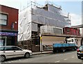
Stamford Street Methodist Church
The former Methodist church is covered in scaffolding and is being converted into apartments.
Image: © Gerald England
Taken: 3 Jun 2010
0.04 miles
9
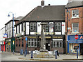
The Feathers
Old Square, Stamford Street.
Ashton grew rapidly from a hamlet to a small town during the second half of the eighteenth century due to an influx of people from the countryside attracted by the prospect of work in the emerging textiles industry (as with Lancashire’s other “cotton towns”. It was during this time, that the town was first laid out with Stamford Street as its “spine” and other smaller streets running parallel to it.
Like other “squares” in the town, Old Square is not really a square, more an octagon. Its original name of The Circus was probably more appropriate. It was re-named King's Square and then again to Old Square some time around the 1780s, when New Square was created at the other end of Stamford Street. New Square, however, was renamed Henry Square in 1800, while Old Square has remained Old Square until this day (https://ashton-under-lyne.blogspot.com/2013/05/old-square.html Ashton-Under-Lyne Photblog).
Only a few of the original three storey buildings remain, with the others having been rebuilt at various times. The Feathers public was first licensed in 1812 and called the Kings Head. Its name was changed to The Feathers in 1842.
Image: © David Dixon
Taken: 4 Jun 2011
0.04 miles
10
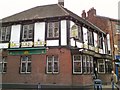
The Feathers
First licensed in 1812 and called the Kings Head. It was changed to The Feathers in 1842. It has been a John Smith's pub since 1939.
Image: © Gerald England
Taken: 31 Oct 2011
0.04 miles