IMAGES TAKEN NEAR TO
Cobden Street, ASHTON-UNDER-LYNE, OL6 6TQ
Introduction
This page details the photographs taken nearby to Cobden Street, OL6 6TQ by members of the Geograph project.
The Geograph project started in 2005 with the aim of publishing, organising and preserving representative images for every square kilometre of Great Britain, Ireland and the Isle of Man.

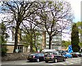
There are currently over 7.5m images from over14,400 individuals and you can help contribute to the project by visiting https://www.geograph.org.uk
Image Map
Images are licensed for reuse under creativecommons.org/licenses/by-sa/2.0
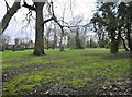
Notes
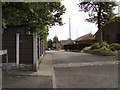
- Clicking on the map will re-center to the selected point.
- The higher the marker number, the further away the image location is from the centre of the postcode.
Image Listing (81 Images Found)
Images are licensed for reuse under creativecommons.org/licenses/by-sa/2.0
Image
Details
Distance
1
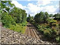
Lines to Stalybridge
The line from Manchester Victoria via Ashton (Charlesworth) to Stalybridge from the bridge on Stamford Street East.
Image: © Gerald England
Taken: 29 Jul 2015
0.02 miles
2
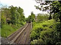
Lines to Stalybridge
Lines from Manchester Victoria to Stalybridge viewed from Stamford Road East.
Image: © Gerald England
Taken: 20 May 2010
0.02 miles
3
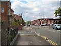
Stamford Road East
The A635 into Ashton under Lyne.
Image: © Gerald England
Taken: 20 May 2010
0.03 miles
4
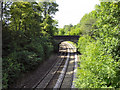
Railway from Stamford Street East
Looking north west along the railway as it passes Tameside College.
Image: © David Dixon
Taken: 14 Jun 2011
0.04 miles
5
Tameside College
Entrance from Stamford Road East.
Image: © Gerald England
Taken: 20 May 2010
0.05 miles
6
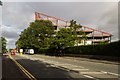
Tameside College
New building at Tameside College.
Image: © Peter McDermott
Taken: 29 Aug 2015
0.06 miles
7
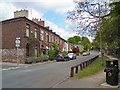
Currier Lane
The original route from Ashton to Stalybridge.
Image: © Gerald England
Taken: 20 May 2010
0.06 miles
8
Graveyard off Currier Lane
The view from Grafton Street.
Image: © Gerald England
Taken: 20 May 2010
0.06 miles
9
Mabs Court
Originally a large house on Currier Lane. Now a small development of bungalows. From the end of Mabs Court, a footpath leads to Bank Top.
Image: © Gerald England
Taken: 20 May 2010
0.07 miles
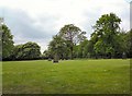
10
Ashton-under-Lyne, former cemetery
On Grafton Street; a few memorials remain, but the cemetery is now an open space.
Image: © Mike Faherty
Taken: 8 Feb 2019
0.07 miles