
IMAGES TAKEN NEAR TO
Stamford Square, ASHTON-UNDER-LYNE, OL6 6QU
Introduction
This page details the photographs taken nearby to Stamford Square, OL6 6QU by members of the Geograph project.
The Geograph project started in 2005 with the aim of publishing, organising and preserving representative images for every square kilometre of Great Britain, Ireland and the Isle of Man.

There are currently over 7.5m images from over14,400 individuals and you can help contribute to the project by visiting https://www.geograph.org.uk
Image Map
Images are licensed for reuse under creativecommons.org/licenses/by-sa/2.0
Notes
- Clicking on the map will re-center to the selected point.
- The higher the marker number, the further away the image location is from the centre of the postcode.
Image Listing (129 Images Found)
Images are licensed for reuse under creativecommons.org/licenses/by-sa/2.0
Image
Details
Distance
1
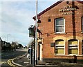
The Sycamore
A Robinsons pub on the corner of Mellor Road and Stamford Road, the A635 from Wakefield and Stalybridge to Ashton and Manchester.
Image: © Gerald England
Taken: 30 Oct 2013
0.01 miles
2
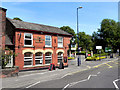
The Sycamore
Public house at the corner of Stamford Square and Mellor Road, next to Stamford Park.
Image: © David Dixon
Taken: 14 Jun 2011
0.02 miles
4
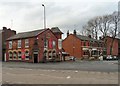
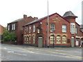
Sycamore Inn
At the bottom of Mellor Road.
Image
Image: © Gerald England
Taken: 11 Feb 2011
0.02 miles
5
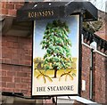
Sign of the Sycamore
Sign for the Sycamore Image
Image: © Gerald England
Taken: 11 Feb 2011
0.02 miles
6
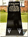
Cockbrook War Memorial
A new memorial, unveiled in 2010, 92 years after the end of the First World War (see Tameside press release http://public.tameside.gov.uk/pressreleases/f1030pressreleasestory107.asp?story=5310&keyword= ).
The black granite obelisk is about 5 ft tall, it stands on Stamford Street, close to St Gabriel’s Church and was first used on Remembrance Sunday (November 14) 2010.
At the top of the obelisk, there is the inscription (in gold lettering) “In proud memory of the men and women who gave their lives at the call of their country in the two world wars and in the years since 1945. We will remember them.”
At the bottom of the monument, two poppy sprays are engraved in white.
(See also: Image])
Image: © David Dixon
Taken: 14 Jun 2011
0.03 miles
7
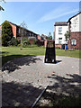
Cockbrook War Memorial
A new memorial, unveiled in 2010, 92 years after the end of the First World War (see Tameside press release http://public.tameside.gov.uk/pressreleases/f1030pressreleasestory107.asp?story=5310&keyword= ).
The black granite obelisk is about 5 ft tall, it stands on Stamford Street, close to St Gabriel’s Church and was first used on Remembrance Sunday (November 14) 2010.
At the top of the obelisk, there is the inscription (in gold lettering) “In proud memory of the men and women who gave their lives at the call of their country in the two world wars and in the years since 1945. We will remember them.”
At the bottom of the monument, two poppy sprays are engraved in white.
Image: © David Dixon
Taken: 14 Jun 2011
0.03 miles
8

Old Boundary Marker in Stamford Park, Tameside
Municipal Boundary Marker in the southwest corner of Stamford Park. On the former boundary of Stalybridge, Cheshire and Ashton-under-Lyne, Lancashire but now entirely in an unparished area of Tameside Metropolitan District. MB is assumed to indicate Municipal Borough.
Milestone Society National ID: CH_STAAUL161pb
Image: © D Garside
Taken: 25 Feb 2022
0.04 miles
10
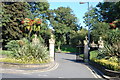
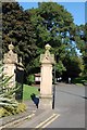
Ashton under Lyne : Coronation Gate
The Coronation Gates were erected in the 1950s at both the Ashton under Lyne and Stalybridge entrances to Stamford Park.
Image: © Ken Bagnall
Taken: 12 Sep 2009
0.05 miles