
IMAGES TAKEN NEAR TO
Warrington Street, ASHTON-UNDER-LYNE, OL6 6DW
Introduction
This page details the photographs taken nearby to Warrington Street, OL6 6DW by members of the Geograph project.
The Geograph project started in 2005 with the aim of publishing, organising and preserving representative images for every square kilometre of Great Britain, Ireland and the Isle of Man.

There are currently over 7.5m images from over14,400 individuals and you can help contribute to the project by visiting https://www.geograph.org.uk
Image Map
Images are licensed for reuse under creativecommons.org/licenses/by-sa/2.0
Notes
- Clicking on the map will re-center to the selected point.
- The higher the marker number, the further away the image location is from the centre of the postcode.
Image Listing (541 Images Found)
Images are licensed for reuse under creativecommons.org/licenses/by-sa/2.0
Image
Details
Distance
1
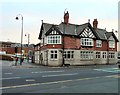
Prince of Orange
Although the public house dates back to 1817, it was rebuilt in 1926 after being taken over by Robinson's Brewery. Mock-Tudor timbered gables were fashionable in that period.
Image: © Gerald England
Taken: 18 Dec 2012
0.00 miles
2
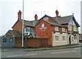
Prince of Orange
Although the public house dates back to 1817, it was rebuilt in 1926 after being taken over by Robinson's Brewery.
Image: © Gerald England
Taken: 18 Jan 2017
0.00 miles
3
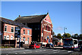
Ashton: Independent Methodist church
Looking east. The bus and Metrolink stations are behind the camera to the right, and the railway station is up on the left beyond the church.
Image: © Dr Neil Clifton
Taken: 24 Oct 2013
0.01 miles
4
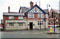
Prince of Orange
The Prince of Orange at the corner of Warrington Street and Wellington Road. The pub dates back to at least 1817. It was taken over by Robinson's in 1920 and rebuilt in 1926. To the left is vehicle access to the multi-storey Arcades car park and pedestrian access to either the Market ground or the bus station. Across Wellington Road is the Independent Methodist Church.
Image: © Gerald England
Taken: 5 Nov 2009
0.01 miles
5

View from the railway station
Beyond the ivy clad wall is Robinsons' Prince of Orange. Behind that is the recently opened Ashton-under-Lyne Interchange next to the tram station. In the background is the residential Assheton House.
Image: © Gerald England
Taken: 4 Nov 2020
0.01 miles
6
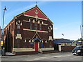
Independent Methodist Church, Wellington Road
Image: © Stephen Armstrong
Taken: 1 Jul 2011
0.02 miles
7
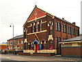
Independent Methodist Church, Wellington Road
The Independent Methodist Church on Wellington Road has the date "AD 1877" on the front gable end.
Image: © David Dixon
Taken: 25 Oct 2012
0.02 miles
8
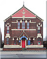
Independent Methodist Church, Ashton
The datestone above the triple window proclaims 877, but that is simply because the 1 has disappeared. The band below the pink gable also shows the remains of an inscription "Independent Methodist Chapel" which appears to have been deliberately removed, which is puzzling in view of the fact that it is still an Independent congregation.
Image: © Alan Murray-Rust
Taken: 7 Jan 2014
0.02 miles
9
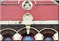
AD 1877
Architectural detail on the former church Image
Image: © Gerald England
Taken: 30 Dec 2017
0.02 miles
10
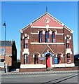
Ashton under Lyne Independent Methodist Church
The church dates from 1877.
Image: © Gerald England
Taken: 7 Mar 2010
0.02 miles