IMAGES TAKEN NEAR TO
Boundary Close, ASHTON-UNDER-LYNE, OL5 9QE
Introduction
This page details the photographs taken nearby to Boundary Close, OL5 9QE by members of the Geograph project.
The Geograph project started in 2005 with the aim of publishing, organising and preserving representative images for every square kilometre of Great Britain, Ireland and the Isle of Man.

There are currently over 7.5m images from over14,400 individuals and you can help contribute to the project by visiting https://www.geograph.org.uk
Image Map (Loading...)


Getting Data...Please wait
Leaflet Map data © OpenStreetMap
Images are licensed for reuse under creativecommons.org/licenses/by-sa/2.0
Notes
- Clicking on the map will re-center to the selected point.
- The higher the marker number, the further away the image location is from the centre of the postcode.
Image Listing (36 Images Found)
Images are licensed for reuse under creativecommons.org/licenses/by-sa/2.0
Image
Details
Distance
1
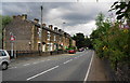
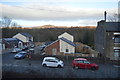
Terraced houses at Blackrock
This is on Manchester Road between Heyrod and Mossley.
Image: © Bill Boaden
Taken: 5 Aug 2010
0.02 miles
2
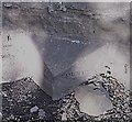
Old Boundary Marker by the A635, Manchester Road, Mossley
County Boundary Marker against a stone wall on the west side of the A635 Manchester Road junction just north of railway tunnel opposite the junction with Blackrock. On the former boundary of Mossley, Lancashire and Stalybridge, Cheshire, but now Mossley, Lancashire and Tameside. Only the inscriptions COUNTY OF can be read on both faces, with the remainder potentially below ground level, and BOUNDARY on the bevelled top face.
Surveyed
Milestone Society National ID: LA_MOSSTA03cb
Image: © Milestone Society
Taken: Unknown
0.04 miles
3
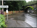
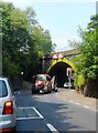
Low Bridge
This low 14ft 9in bridge, that carries the main Manchester to Leeds railway line, is on the A635 Wakefield Road between Mossley and Stalybridge.
Picture taken on a rain soaked miserable July afternoon during one of the wettest summers ever recorded
Image: © Paul Anderson
Taken: 26 Jul 2007
0.04 miles
4
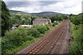
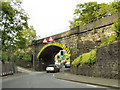
The railway line between Mossley and Stalybridge
This is at Blackrock just north of Heyrod. Hollingworthall Moor is behind.
Image: © Bill Boaden
Taken: 5 Aug 2010
0.05 miles
8

The Huddersfield Narrow Canal
The pound between Avenue Lock [10W] and Terrace Lock [11W].
Image: © Christine Johnstone
Taken: 18 May 2010
0.07 miles
9
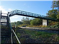
Footbridge over railway near Mossley
Crossing the line from Leeds to Manchester.
Image: © JThomas
Taken: 2 Nov 2018
0.09 miles
10

Woodland east of the canal
Young trees have colonised a disused railway line.
Image: © Christine Johnstone
Taken: 18 May 2010
0.11 miles