IMAGES TAKEN NEAR TO
Bottoms Fold, ASHTON-UNDER-LYNE, OL5 9NH
Introduction
This page details the photographs taken nearby to Bottoms Fold, OL5 9NH by members of the Geograph project.
The Geograph project started in 2005 with the aim of publishing, organising and preserving representative images for every square kilometre of Great Britain, Ireland and the Isle of Man.

There are currently over 7.5m images from over14,400 individuals and you can help contribute to the project by visiting https://www.geograph.org.uk
Image Map (Loading...)


Getting Data...Please wait
Leaflet Map data © OpenStreetMap
Images are licensed for reuse under creativecommons.org/licenses/by-sa/2.0
Notes
- Clicking on the map will re-center to the selected point.
- The higher the marker number, the further away the image location is from the centre of the postcode.
Image Listing (126 Images Found)
Images are licensed for reuse under creativecommons.org/licenses/by-sa/2.0
Image
Details
Distance
2
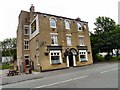
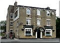
The Bridge Inn
Micklehurst Road, Bottoms, Mossley.
Image: © Gerald England
Taken: 2 May 2012
0.03 miles
3
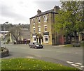
New Bridge Inn
On Micklehurst Road at Bottoms.
Image: © Gerald England
Taken: 22 Jun 2009
0.03 miles
4
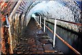
Scout tunnel
Scout tunnel is situated on the Huddersfield narrow canal between Stalybridge and Mossley, Lancashire.
Scout tunnel is 616 ft (205 yds) long and is carved out of solid rock.
The Huddersfield Narrow Canal runs for 20 miles between Huddersfield in West Yorkshire and Ashton under Lyne in Greater Manchester.
Standedge Tunnel 5 miles away is Britain's longest canal tunnel at 3.25 miles long. This was one of our recent explores a few weeks earlier.
*You can read my full Subterranea Standedge-A trip back in time story here http://blogs.myspace.com/index.cfm?fuseaction=blog.view&friendId=265602590&blogId=499903956
Image: © philld
Taken: 9 Aug 2009
0.04 miles
5
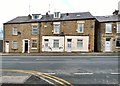
##2-10 Micklehurst Road
Above #6 Image is a name and date stone bearing the words "Ponge Buildings 1885" Image In the wall of #8 is a Victorian letterbox (OL5 114) Image
Image: © Gerald England
Taken: 18 Feb 2016
0.04 miles
6
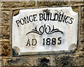
Ponge Buildings AD 1885
Name and date stone above #6 Micklehurst Road Image, Mossley.
Image: © Gerald England
Taken: 18 Feb 2016
0.04 miles
7
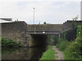
Huddersfield Narrow Canal, Bridge 91
Known as Bottoms Bridge it carries Micklehurst Road over the canal.
Image: © Richard Rogerson
Taken: 9 Jul 2017
0.05 miles
8
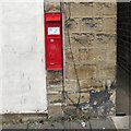
V R Postbox (OL5 114)
A thin Victorian wall box (OL5 114) on the wall of the Ponge Buildings Image on Micklehurst Road Image
Image: © Gerald England
Taken: 18 Feb 2016
0.05 miles
9
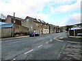
Micklehurst Road
The first group of houses on the left are the Ponge Buildings Image There is a Victorian letterbox Image in the wall of one house.
Image: © Gerald England
Taken: 18 Feb 2016
0.05 miles
10
![Bottoms Bridge [no. 91]](https://s3.geograph.org.uk/geophotos/01/88/01/1880195_2065a284_120x120.jpg)
Bottoms Bridge [no. 91]
The church at Mossley Brow is on the skyline.
Image: © Christine Johnstone
Taken: 18 May 2010
0.05 miles