IMAGES TAKEN NEAR TO
Woodbank Terrace, ASHTON-UNDER-LYNE, OL5 0SP
Introduction
This page details the photographs taken nearby to Woodbank Terrace, OL5 0SP by members of the Geograph project.
The Geograph project started in 2005 with the aim of publishing, organising and preserving representative images for every square kilometre of Great Britain, Ireland and the Isle of Man.

There are currently over 7.5m images from over14,400 individuals and you can help contribute to the project by visiting https://www.geograph.org.uk
Image Map (Loading...)


Getting Data...Please wait
Leaflet Map data © OpenStreetMap
Images are licensed for reuse under creativecommons.org/licenses/by-sa/2.0
Notes
- Clicking on the map will re-center to the selected point.
- The higher the marker number, the further away the image location is from the centre of the postcode.
Image Listing (43 Images Found)
Images are licensed for reuse under creativecommons.org/licenses/by-sa/2.0
Image
Details
Distance
1
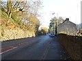
Manchester Road (A635)
Looking north east, Woodend.
Image: © JThomas
Taken: 15 Nov 2018
0.05 miles
3

New Earth Street Mossley
These houses near, to the centre of Mossley, are on a very steep hill.
In winter this street can be a nightmare when it snows or is covered in ice.
Image: © Paul Anderson
Taken: 30 Mar 2007
0.07 miles
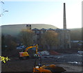
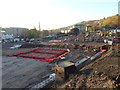
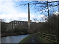
5
Old mill at Woodend
Beside Huddersfield Narrow Canal
Image: © Chris Morgan
Taken: 18 Mar 2019
0.10 miles
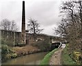
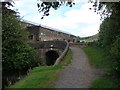
6
Huddersfield Narrow Canal near Woodend
Image: © Chris Wimbush
Taken: 5 Mar 2009
0.11 miles
9
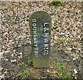
Old Boundary Post
For the LNWR on Winterton Lane near the canal bridge. The post is much closer to the canal than the railway and presumably was erected when the canal was in railway ownership.
Image: © Kevin Waterhouse
Taken: 19 Mar 2023
0.14 miles
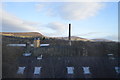
10
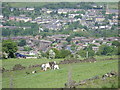
Micklehurst with Roughtown in the distance
Image: © Richard Brierley
Taken: 1 Jun 2009
0.14 miles