IMAGES TAKEN NEAR TO
Hart Court, ASHTON-UNDER-LYNE, OL5 0NS
Introduction
This page details the photographs taken nearby to Hart Court, OL5 0NS by members of the Geograph project.
The Geograph project started in 2005 with the aim of publishing, organising and preserving representative images for every square kilometre of Great Britain, Ireland and the Isle of Man.

There are currently over 7.5m images from over14,400 individuals and you can help contribute to the project by visiting https://www.geograph.org.uk
Image Map (Loading...)


Getting Data...Please wait
Leaflet Map data © OpenStreetMap
Images are licensed for reuse under creativecommons.org/licenses/by-sa/2.0
Notes
- Clicking on the map will re-center to the selected point.
- The higher the marker number, the further away the image location is from the centre of the postcode.
Image Listing (62 Images Found)
Images are licensed for reuse under creativecommons.org/licenses/by-sa/2.0
Image
Details
Distance
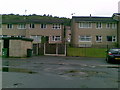
1

Unsightly housing development in Mossley
Image: © Bill Boaden
Taken: 31 Jan 2009
0.04 miles
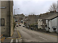
2

Brook Bottom
Footbridge from Lees Road leading to houses on the Brook Bottom estate.
Image: © Gerald England
Taken: 2 May 2012
0.07 miles
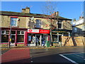
5
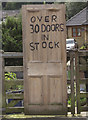
Old doors for sale
Seen at the end of Lees Road, Top Mossley. It belongs to an antique shop to the left (out of shot).
Image: © michael ely
Taken: 23 Aug 2008
0.14 miles
6
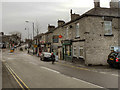
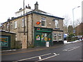
Post Office, Top Mossley
Row of shops including the post office on Lees Road, Top Mossley
Image: © David Dixon
Taken: 12 Dec 2011
0.14 miles
7

Upper Mossley Post Office
On Lees Road.
Image: © Gerald England
Taken: 12 Aug 2009
0.14 miles