IMAGES TAKEN NEAR TO
Co-Operative Street, OLDHAM, OL4 5TB
Introduction
This page details the photographs taken nearby to Co-Operative Street, OL4 5TB by members of the Geograph project.
The Geograph project started in 2005 with the aim of publishing, organising and preserving representative images for every square kilometre of Great Britain, Ireland and the Isle of Man.

There are currently over 7.5m images from over14,400 individuals and you can help contribute to the project by visiting https://www.geograph.org.uk
Image Map
Images are licensed for reuse under creativecommons.org/licenses/by-sa/2.0
Notes
- Clicking on the map will re-center to the selected point.
- The higher the marker number, the further away the image location is from the centre of the postcode.
Image Listing (45 Images Found)
Images are licensed for reuse under creativecommons.org/licenses/by-sa/2.0
Image
Details
Distance
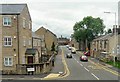
1
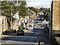
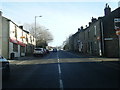
Oldham Road (A669)
The A669, Oldham Road, between Lees and Springhead.
Image: © David Dixon
Taken: 13 Oct 2011
0.03 miles
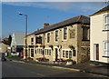
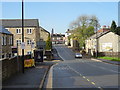
7
County End
The A669 approaching Lees. County End was originally the boundary between Springhead, Saddleworth, West Riding of Yorkshire and Lees, Oldham, Lancashire. Now it all comes under Oldham, Greater Manchester.
Image: © Gerald England
Taken: 3 Jul 2013
0.07 miles
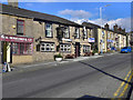
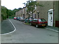
8
New housing on the High Street at Lees
Image: © Raymond Knapman
Taken: 20 Jul 2012
0.07 miles
10
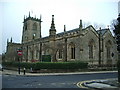
St Thomas the Apostle Church, Leesfield
Image: © Alexander P Kapp
Taken: 12 Feb 2009
0.10 miles