IMAGES TAKEN NEAR TO
Stonelands Way, OLDHAM, OL4 5SU
Introduction
This page details the photographs taken nearby to Stonelands Way, OL4 5SU by members of the Geograph project.
The Geograph project started in 2005 with the aim of publishing, organising and preserving representative images for every square kilometre of Great Britain, Ireland and the Isle of Man.

There are currently over 7.5m images from over14,400 individuals and you can help contribute to the project by visiting https://www.geograph.org.uk
Image Map
Images are licensed for reuse under creativecommons.org/licenses/by-sa/2.0
Notes
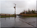
- Clicking on the map will re-center to the selected point.
- The higher the marker number, the further away the image location is from the centre of the postcode.
Image Listing (11 Images Found)
Images are licensed for reuse under creativecommons.org/licenses/by-sa/2.0
Image
Details
Distance
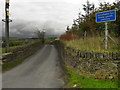
2
Grotton from the Oldham Way
This is where the Oldham Way climbs up Quick Edge. There are usually lively and noisy dogs in this field.
Image: © Bill Boaden
Taken: 29 May 2010
0.18 miles
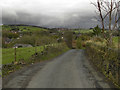
4
Thornely Lane
From the end of Under Lane, Grotton.
Image: © Gerald England
Taken: 2 May 2012
0.19 miles
6
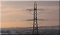
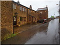
Grotton, Oldham: pylon and mills
Old and modern juxtaposed at Grotton, on the western fringe of Saddleworth. The chimney in the background is one of the few remaining in Oldham, which once had dozens of steam-powered cotton mills.
Image: © Michael Fox
Taken: 7 Dec 2010
0.21 miles
7
Grotton & Springhead station (remains), 1997
View eastward, towards Greenfield: ex-LNWR Greenfield - Oldham line. The station was closed when passenger services ceased from 2/5/55, but the line remained for freight until 4/64.
Image: © Ben Brooksbank
Taken: 8 Jul 1997
0.22 miles
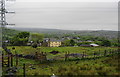
8
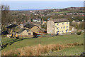
Lower Quick Edge
This old hamlet, seen from the Oldham Way footpath, has almost been engulfed by the large housing estates that have developed on the eastern side of Oldham.
Image: © Michael Fox
Taken: 11 Apr 2010
0.23 miles
9
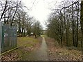
Route of former railway at Grotton
View from the former Grotton Station towards Lees on the Greenfield to Oldham railway route. A cycle path exists on the Grotton to Oldham portion of the route.
Image: © Kevin Waterhouse
Taken: 10 Feb 2023
0.24 miles