IMAGES TAKEN NEAR TO
Shade Avenue, OLDHAM, OL4 5SB
Introduction
This page details the photographs taken nearby to Shade Avenue, OL4 5SB by members of the Geograph project.
The Geograph project started in 2005 with the aim of publishing, organising and preserving representative images for every square kilometre of Great Britain, Ireland and the Isle of Man.

There are currently over 7.5m images from over14,400 individuals and you can help contribute to the project by visiting https://www.geograph.org.uk
Image Map
Images are licensed for reuse under creativecommons.org/licenses/by-sa/2.0
Notes
- Clicking on the map will re-center to the selected point.
- The higher the marker number, the further away the image location is from the centre of the postcode.
Image Listing (30 Images Found)
Images are licensed for reuse under creativecommons.org/licenses/by-sa/2.0
Image
Details
Distance
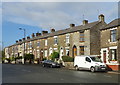
2
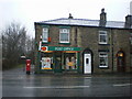
Springhead Post Office, Oldham Road
Image: © Alexander P Kapp
Taken: 27 Jan 2009
0.10 miles
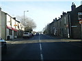
3
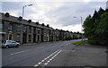
Oldham Road, Springhead
This is at the junction with Ashbrook Road.
Image: © Bill Boaden
Taken: 12 Jun 2010
0.11 miles
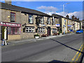
4
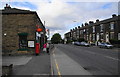
Oldham Road, Springhead
Springhead Post Office is on the left.
Image: © Bill Boaden
Taken: 12 Jun 2010
0.11 miles
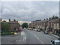
6
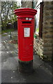
Elizabeth II postbox on Oldham Road, Springhead
Outside the former Post Office.
Postbox No. OL4 28.
See Image] for context.
Image: © JThomas
Taken: 2 Nov 2018
0.11 miles
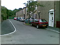
7
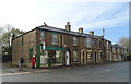
Former Post Office on Oldham Road, Springhead
Showing position of Postbox No. OL4 28.
See Image] for postbox.
Image: © JThomas
Taken: 2 Nov 2018
0.11 miles