IMAGES TAKEN NEAR TO
Furberry Court, OLDHAM, OL4 5JH
Introduction
This page details the photographs taken nearby to Furberry Court, OL4 5JH by members of the Geograph project.
The Geograph project started in 2005 with the aim of publishing, organising and preserving representative images for every square kilometre of Great Britain, Ireland and the Isle of Man.

There are currently over 7.5m images from over14,400 individuals and you can help contribute to the project by visiting https://www.geograph.org.uk
Image Map
Images are licensed for reuse under creativecommons.org/licenses/by-sa/2.0
Notes
- Clicking on the map will re-center to the selected point.
- The higher the marker number, the further away the image location is from the centre of the postcode.
Image Listing (25 Images Found)
Images are licensed for reuse under creativecommons.org/licenses/by-sa/2.0
Image
Details
Distance
1
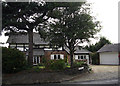
Sycamore Lodge, Grotton
A large house on Coverhill Road between Grotton and Mossley.
Image: © michael ely
Taken: 8 Jul 2010
0.10 miles
2
Green View Chase, Grotton
Green View Chase is a recently built, mini modern housing estate, composed of detached and semi-detached stone properties. It is located in Grotton, which is a desirable and affluent part of Saddleworth and the Metropolitan Borough of Oldham, in Greater Manchester.
Image: © Steven Haslington
Taken: 15 May 2012
0.12 miles
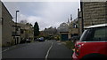
4
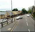
Oldham Road, Grotton
The A669 at its junction with Coverhill Road.
Image: © Gerald England
Taken: 3 Jul 2013
0.15 miles
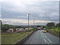
5

Grotton, Oldham: pylon and mills
Old and modern juxtaposed at Grotton, on the western fringe of Saddleworth. The chimney in the background is one of the few remaining in Oldham, which once had dozens of steam-powered cotton mills.
Image: © Michael Fox
Taken: 7 Dec 2010
0.16 miles
6
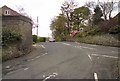
Thornely Lane
From the end of Under Lane, Grotton.
Image: © Gerald England
Taken: 2 May 2012
0.17 miles
7
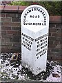
Old Milestone by the A669, Oldham Road, Grotton
Metal plate attached to stone post by the A669, in parish of SADDLEWORTH (OLDHAM District), Grotton, 100m West of Coverhill road, by Hills Avenue, by garden wall at back of pavement, on South side of road. Brayshaw & Booth iron casting, erected by the County Council in the 19th century.
Inscription reads:-
: MANCHESTER / 9¾ MILES / OLDHAM / 2¾ MILES : : OLDHAM & STANDEDGE / ROAD / QUICKMERE L D : : HUDDERSFIELD / 16 MILES / HOLMFIRTH / 12½ MILES / UPPERMILL / 2½ MILES :
Maker:-
: BRAYSHAW & BOOTH / MAKERS / LIVERSEDGE :
Milestone Society National ID: YW_ODSD02.
Image: © C Minto
Taken: 11 May 2012
0.17 miles
8
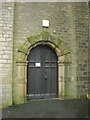
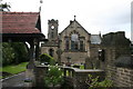
The Church of St Anne, Lydgate, Doorway
Image: © Alexander P Kapp
Taken: 27 Jan 2009
0.21 miles
9
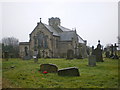
The Church of St Anne, Lydgate
http://www.saddleworthteam-cofe.org.uk/St%20Annes%20home%20page.html
Image: © Alexander P Kapp
Taken: 27 Jan 2009
0.22 miles