IMAGES TAKEN NEAR TO
Malta Street, OLDHAM, OL4 5HS
Introduction
This page details the photographs taken nearby to Malta Street, OL4 5HS by members of the Geograph project.
The Geograph project started in 2005 with the aim of publishing, organising and preserving representative images for every square kilometre of Great Britain, Ireland and the Isle of Man.

There are currently over 7.5m images from over14,400 individuals and you can help contribute to the project by visiting https://www.geograph.org.uk
Image Map
Images are licensed for reuse under creativecommons.org/licenses/by-sa/2.0
Notes
- Clicking on the map will re-center to the selected point.
- The higher the marker number, the further away the image location is from the centre of the postcode.
Image Listing (40 Images Found)
Images are licensed for reuse under creativecommons.org/licenses/by-sa/2.0
Image
Details
Distance
1
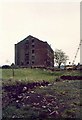
Sett Mill, Salem (Sett), Oldham
The Sett Mill stood on Gibraltar Street, Oldham, it was also known as the Gibraltar Mill. Built around 1838 it was demolished in the early 1980's and the site used for houses.
Image: © M Campbell
Taken: Unknown
0.00 miles
2
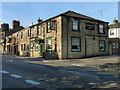
Lighthouse Inn
The Lighthouse Inn at the corner of Lees Road and Ogden Street.
Image: © David Dixon
Taken: 13 Oct 2011
0.03 miles
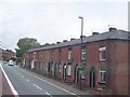
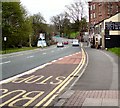
5
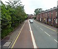
Lees Road, Salem
As the A669 climbs out of Lees towards Oldham, a bus lane is provided on the Oldham bound side.
Image: © Gerald England
Taken: 3 Jul 2013
0.07 miles
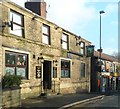
6
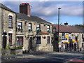
Friendship Inn
The Friendship Inn on Lees Road, Salem, Oldham.
Image: © David Dixon
Taken: 13 Oct 2011
0.08 miles
7
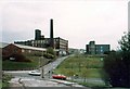
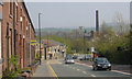
Bank Top Mill, Edmund Street, Oldham
The Bank Top Mill was built in 1875. When I took the photograph it was owned by Newroyds. The low buildings in front of the Bank Top are on the site of the Clarksfield Mill. Wellyhole Street, a former Roman road, runs up the centre of the photograph. The Windsor Mill, formerly the Egyptian Mill built about 1836, is across Wellyhole St from the Bank Top. It ended its days as a warehouse for Newroyds. Houses now stand on the sites of all three mills.
Image: © M Campbell
Taken: Unknown
0.08 miles
8
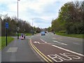
Lees Road
The A669 Greenfield to Middleton road at Leesbrook entering Oldham.
Image: © Gerald England
Taken: 2 May 2012
0.09 miles
9
Salem
Looking east down the A669 Lees Road, Salem, Oldham. Lees Church is right of centre and Lydgate Church is visible on the horizon.
Image: © Martin Clark
Taken: Unknown
0.10 miles
10
Lees Road
The A669 at Lees Bridge leading into High Street, Lees.
Image: © Gerald England
Taken: 2 May 2012
0.11 miles