IMAGES TAKEN NEAR TO
Lees Road, OLDHAM, OL4 5EY
Introduction
This page details the photographs taken nearby to Lees Road, OL4 5EY by members of the Geograph project.
The Geograph project started in 2005 with the aim of publishing, organising and preserving representative images for every square kilometre of Great Britain, Ireland and the Isle of Man.

There are currently over 7.5m images from over14,400 individuals and you can help contribute to the project by visiting https://www.geograph.org.uk
Image Map
Images are licensed for reuse under creativecommons.org/licenses/by-sa/2.0
Notes
- Clicking on the map will re-center to the selected point.
- The higher the marker number, the further away the image location is from the centre of the postcode.
Image Listing (18 Images Found)
Images are licensed for reuse under creativecommons.org/licenses/by-sa/2.0
Image
Details
Distance
1
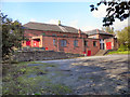
Salem Moravian Church, Lees Road
A late twentieth century building which replaced the original Moravian church in Clarksfield, Oldham. According to this http://en.wikipedia.org/wiki/Salem_Moravian_Church , on Wikipedia, the original church here was founded in 1825 by Brother John Lees, a prosperous member of the Fairfield Moravian (http://www.geograph.org.uk/snippet/1336 ) congregation.
Image: © David Dixon
Taken: 13 Oct 2011
0.03 miles
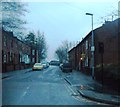
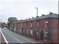
3
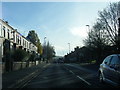
Salem
Looking east down the A669 Lees Road, Salem, Oldham. Lees Church is right of centre and Lydgate Church is visible on the horizon.
Image: © Martin Clark
Taken: Unknown
0.05 miles
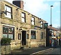
4
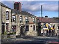
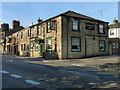
Friendship Inn
The Friendship Inn on Lees Road, Salem, Oldham.
Image: © David Dixon
Taken: 13 Oct 2011
0.08 miles
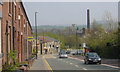
5
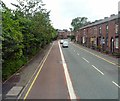
Lees Road, Salem
As the A669 climbs out of Lees towards Oldham, a bus lane is provided on the Oldham bound side.
Image: © Gerald England
Taken: 3 Jul 2013
0.08 miles
7
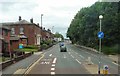
End of Bus Lane
The bus lane on the A669 from Lees through Salem ends at Clarksfield.
Image: © Gerald England
Taken: 3 Jul 2013
0.10 miles
9
A669 Lees Road nearing Clarksfield Road junction
Image: © Colin Pyle
Taken: 19 Nov 2017
0.13 miles
10
Lighthouse Inn
The Lighthouse Inn at the corner of Lees Road and Ogden Street.
Image: © David Dixon
Taken: 13 Oct 2011
0.15 miles