IMAGES TAKEN NEAR TO
Link Road, OLDHAM, OL4 4SF
Introduction
This page details the photographs taken nearby to Link Road, OL4 4SF by members of the Geograph project.
The Geograph project started in 2005 with the aim of publishing, organising and preserving representative images for every square kilometre of Great Britain, Ireland and the Isle of Man.

There are currently over 7.5m images from over14,400 individuals and you can help contribute to the project by visiting https://www.geograph.org.uk
Image Map
Images are licensed for reuse under creativecommons.org/licenses/by-sa/2.0
Notes
- Clicking on the map will re-center to the selected point.
- The higher the marker number, the further away the image location is from the centre of the postcode.
Image Listing (30 Images Found)
Images are licensed for reuse under creativecommons.org/licenses/by-sa/2.0
Image
Details
Distance

4
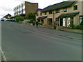
Stamford Road, Lees
Stone terraced housing on Stamford Road in Lees, Greater Manchester, England. This housing stock is typical of Lees, a predominatly stone-built suburban village adjoining Oldham.
Image: © Steven Haslington
Taken: 30 May 2011
0.13 miles
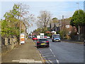
6
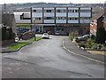
Carr House Road Shops Springhead
Picture taken from The Rise looking down to the shops at the bottom of the hill on Carr House Road.
The church on the horizon is Image
Image: © Paul Anderson
Taken: 21 Mar 2007
0.13 miles
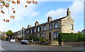
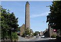
7
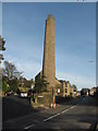
Austerlands Chimney
Built over 200 years ago out of stone Austerlands chimney is a well known local landmark.
Notice the bush growing out of the top.
Image: © Paul Anderson
Taken: 29 Oct 2006
0.15 miles
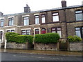
8
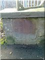
Old Boundary Marker by the A62, Huddersfield Road, Austerlands
County Boundary Marker by the A62, in parish of Oldham (Oldham District), Huddersfield Road, Austerlands, opposite Thorpe Lane in stone structure, next to yard entrance.
Inscription reads vertically:-
YORKSHIRE W.R. / SPRINGHEAD U.D. | LANCASHIRE
Surveyed
Milestone Society National ID: LA_OLHU02cb
Image: © Milestone Society
Taken: Unknown
0.15 miles
10
Austerlands chimney
A rare survivor from the once numerous textile mill chimneys in this area.
Image: © Michael Fox
Taken: 14 Jun 2011
0.16 miles