IMAGES TAKEN NEAR TO
Brighton Road, OLDHAM, OL4 3SE
Introduction
This page details the photographs taken nearby to Brighton Road, OL4 3SE by members of the Geograph project.
The Geograph project started in 2005 with the aim of publishing, organising and preserving representative images for every square kilometre of Great Britain, Ireland and the Isle of Man.

There are currently over 7.5m images from over14,400 individuals and you can help contribute to the project by visiting https://www.geograph.org.uk
Image Map
Images are licensed for reuse under creativecommons.org/licenses/by-sa/2.0
Notes
- Clicking on the map will re-center to the selected point.
- The higher the marker number, the further away the image location is from the centre of the postcode.
Image Listing (13 Images Found)
Images are licensed for reuse under creativecommons.org/licenses/by-sa/2.0
Image
Details
Distance
1
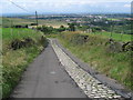
Single Track Road
This single track road is called Back O'th Low Road.
The tall building to the right on the horizon is Image
Image: © Paul Anderson
Taken: 16 Jul 2007
0.12 miles
2
Top o' th' Meadows hamlet
This cluster of old dwellings is high up on the eastern side of Strinesdale.
Image: © Michael Fox
Taken: 14 Jun 2011
0.18 miles
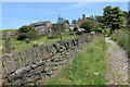
3
The lane to Strines
This is one of a network of tracks and paths that once connected the various farmsteads and hamlets in Strinesdale.
Image: © Michael Fox
Taken: 14 Jun 2011
0.20 miles
4
Warning flags flying
Around Highmoor Clay pigeon Club viewed from Whitegates Lane
Image: © Kevin Waterhouse
Taken: 6 Jan 2023
0.20 miles
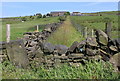
5

Barn at Bar Stacks
Old Maps shows a farm on the right hand side of the lane here but little trace of it remains
Image: © John Slater
Taken: 10 Oct 2015
0.21 miles
6
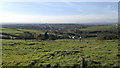
View from Brighton Road, Strinesdale
A view of Oldham, Greater Manchester, and beyond, as seen from Brighton Road in the Strinesdale area of Oldham, in Greater Manchester, England. This outyling part of Oldham is rural and borders on to the parish of Saddleworth.
Image: © Steven Haslington
Taken: 28 Oct 2011
0.22 miles
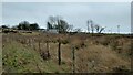
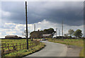
7
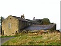
Nebo Farmhouse
Farm buildings on Whitegates Lane at High Moor.
Image: © Roger May
Taken: 9 Oct 2005
0.23 miles
8
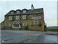
Two Acre Lane junction
This is near its junction with Shilo Lane. The Roebuck Inn can be seen at left of shot.
Image: © michael ely
Taken: 27 Jan 2011
0.24 miles
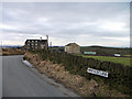
10
Nebo and Whitegates Lane, High Moor
Nebo is one of a number of farmsteads that were established in this upland area as long ago as the seventeenth century.
Image: © Michael Fox
Taken: 18 Sep 2011
0.24 miles