IMAGES TAKEN NEAR TO
Strinesdale, OLDHAM, OL4 3RB
Introduction
This page details the photographs taken nearby to Strinesdale, OL4 3RB by members of the Geograph project.
The Geograph project started in 2005 with the aim of publishing, organising and preserving representative images for every square kilometre of Great Britain, Ireland and the Isle of Man.

There are currently over 7.5m images from over14,400 individuals and you can help contribute to the project by visiting https://www.geograph.org.uk
Image Map
Images are licensed for reuse under creativecommons.org/licenses/by-sa/2.0
Notes
- Clicking on the map will re-center to the selected point.
- The higher the marker number, the further away the image location is from the centre of the postcode.
Image Listing (28 Images Found)
Images are licensed for reuse under creativecommons.org/licenses/by-sa/2.0
Image
Details
Distance
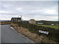
1
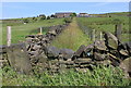
The lane to Strines
This is one of a network of tracks and paths that once connected the various farmsteads and hamlets in Strinesdale.
Image: © Michael Fox
Taken: 14 Jun 2011
0.10 miles
2
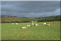
Sheep Pasture, Strine Dale
Sheep in field on the north side of Green Lane. On the skyline left of shot are houses at Moorside.
Image: © michael ely
Taken: 19 Jan 2007
0.10 miles
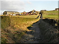
3

Barn at Bar Stacks
Old Maps shows a farm on the right hand side of the lane here but little trace of it remains
Image: © John Slater
Taken: 10 Oct 2015
0.11 miles
4
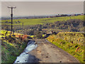
Green Lane, Strinsedale
Looking along Green Lane, towards Strines, from near to the Roebuck Inn.
Image: © David Dixon
Taken: 28 Oct 2011
0.12 miles
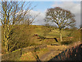
5
Green Lane, Strinedale
Climbing towards the Roebuck Inn.
Image: © michael ely
Taken: 13 May 2012
0.14 miles
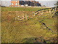
6
Two Acre Lane junction
This is near its junction with Shilo Lane. The Roebuck Inn can be seen at left of shot.
Image: © michael ely
Taken: 27 Jan 2011
0.14 miles
7
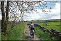
Green Lane, Strinesdale Country Park
Green Lane bridleway, past Green Lane Farm towards Roebuck Lane.
Image: © David Dixon
Taken: 28 Jan 2011
0.17 miles
8
Strinesdale
Strinesdale Country Park, to the north-east of the upper reservoir.
Image: © David Dixon
Taken: 28 Jan 2011
0.17 miles
9
Strinesdale
Footpath above Strinesdale Upper Reservoir.
Image: © David Dixon
Taken: 28 Jan 2011
0.18 miles
10

Path junction at the western end of Green Lane
Image: © John Slater
Taken: 29 Sep 2014
0.19 miles