IMAGES TAKEN NEAR TO
Dyson Grove, OLDHAM, OL4 3PB
Introduction
This page details the photographs taken nearby to Dyson Grove, OL4 3PB by members of the Geograph project.
The Geograph project started in 2005 with the aim of publishing, organising and preserving representative images for every square kilometre of Great Britain, Ireland and the Isle of Man.

There are currently over 7.5m images from over14,400 individuals and you can help contribute to the project by visiting https://www.geograph.org.uk
Image Map
Images are licensed for reuse under creativecommons.org/licenses/by-sa/2.0
Notes
- Clicking on the map will re-center to the selected point.
- The higher the marker number, the further away the image location is from the centre of the postcode.
Image Listing (41 Images Found)
Images are licensed for reuse under creativecommons.org/licenses/by-sa/2.0
Image
Details
Distance
1
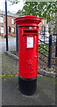
Elizabeth II postbox on Huddersfield Road, Lees
Postbox No. OL4 100.
See Image] for context.
Image: © JThomas
Taken: 2 Nov 2018
0.08 miles
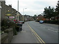
2
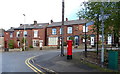
Terraced housing on Huddersfield Road, Lees
Showing position of Postbox No. OL4 100.
See Image] for postbox.
Image: © JThomas
Taken: 2 Nov 2018
0.09 miles
4
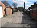
Back Lane Austerlands
This is the rear access lane for the red brick houses on the right that front on to Huddersfield Road.
Image] is at the far end
Image: © Paul Anderson
Taken: 21 Mar 2007
0.11 miles
5
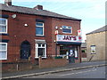
Post Office on Stamford Road
Also an Off Licence and Newsagents.
Image: © JThomas
Taken: 2 Nov 2018
0.11 miles
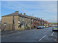
6
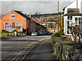
Huddersfield Road
Huddersfield Road (the A62) at Austerlands, looking downhill towards Oldham
Image: © David Dixon
Taken: 28 Oct 2011
0.13 miles
7
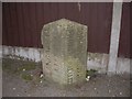
Old Boundary Marker by the A62, Huddersfield Road, Lees
County Boundary Marker by the A62, in parish of Oldham (Oldham District), Huddersfield Road; Lees, 100m West of the (former) Temple PH against fence, South side of road.
Inscription reads vertically:-
: LANCASHIRE / LEES U.D. : : YORKSHIRE W.R. / SPRINGHEAD U.D. :
Surveyed
Milestone Society National ID: LA_OLHU01cb
Image: © Mike Faherty
Taken: 17 Oct 2009
0.13 miles
8
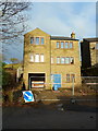
Unfinished house near Austerlands Chimney
The date stone is for 2008, looking at it there does not seem to have been much done from when the roof was finished
Image: © Alexander P Kapp
Taken: 27 Nov 2012
0.16 miles
9
Waterhead, hill
Looking up Huddersfield Road (A62) towards Austerlands; The Temple pub in the foreground.
Image: © Mike Faherty
Taken: 17 Oct 2009
0.17 miles
10
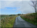
Back O' Th' Low Road
Looking north west towards Back O' Th' Low Farm.
Image: © JThomas
Taken: 2 Nov 2018
0.17 miles