IMAGES TAKEN NEAR TO
Ripponden Road, OLDHAM, OL4 2RU
Introduction
This page details the photographs taken nearby to Ripponden Road, OL4 2RU by members of the Geograph project.
The Geograph project started in 2005 with the aim of publishing, organising and preserving representative images for every square kilometre of Great Britain, Ireland and the Isle of Man.

There are currently over 7.5m images from over14,400 individuals and you can help contribute to the project by visiting https://www.geograph.org.uk
Image Map
Images are licensed for reuse under creativecommons.org/licenses/by-sa/2.0
Notes
- Clicking on the map will re-center to the selected point.
- The higher the marker number, the further away the image location is from the centre of the postcode.
Image Listing (27 Images Found)
Images are licensed for reuse under creativecommons.org/licenses/by-sa/2.0
Image
Details
Distance
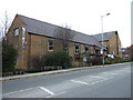
1
Moor Haven Care Home
One of several former large villas on Ripponden Road, Watersheddings, converted to residential care homes
Image: © Kevin Waterhouse
Taken: 6 Apr 2023
0.03 miles
4
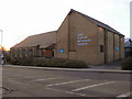
East Oldham Methodist Church
The East Oldham Methodist Church on Ripponden Road, Derker.
Image: © David Dixon
Taken: 28 Jan 2011
0.09 miles
6
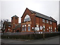
Former St Ambrose Church
Now used as a child nursery.
Image: © Alexander P Kapp
Taken: 30 Jan 2009
0.10 miles

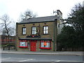
9
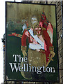
Sign for the Wellington, Oldham (north side)
Image: © JThomas
Taken: 14 Mar 2015
0.11 miles