IMAGES TAKEN NEAR TO
Campion Drive, OLDHAM, OL4 2AW
Introduction
This page details the photographs taken nearby to Campion Drive, OL4 2AW by members of the Geograph project.
The Geograph project started in 2005 with the aim of publishing, organising and preserving representative images for every square kilometre of Great Britain, Ireland and the Isle of Man.

There are currently over 7.5m images from over14,400 individuals and you can help contribute to the project by visiting https://www.geograph.org.uk
Image Map
Images are licensed for reuse under creativecommons.org/licenses/by-sa/2.0
Notes
- Clicking on the map will re-center to the selected point.
- The higher the marker number, the further away the image location is from the centre of the postcode.
Image Listing (11 Images Found)
Images are licensed for reuse under creativecommons.org/licenses/by-sa/2.0
Image
Details
Distance

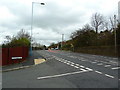
2

Ripponden Road (A672)
Ripponden Road, approaching Wilkes Street, between Watersheddings and Moorside.
Image: © David Dixon
Taken: 28 Jan 2011
0.17 miles
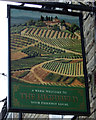
3

The Highfield public house
On Ripponden Road.
Image: © JThomas
Taken: 14 Mar 2015
0.18 miles
4

The Highfield
The Highfield public house.
Image: © Peter McDermott
Taken: 2 Jul 2017
0.18 miles
5

The Highfield, Ripponden Road, Moorside
Image: © Alexander P Kapp
Taken: 22 Nov 2012
0.18 miles
8

Ripponden Road (A672), Watersheddings
Looking along Ripponden Road, from the junction with Radcliffe Road.
Image: © David Dixon
Taken: 28 Jan 2011
0.20 miles
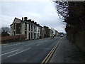
10

Ripponden Road
New housing development off Ripponden Road in Oldham.
Image: © Peter McDermott
Taken: 2 Jul 2017
0.22 miles