IMAGES TAKEN NEAR TO
Swinton Street, OLDHAM, OL4 1QS
Introduction
This page details the photographs taken nearby to Swinton Street, OL4 1QS by members of the Geograph project.
The Geograph project started in 2005 with the aim of publishing, organising and preserving representative images for every square kilometre of Great Britain, Ireland and the Isle of Man.

There are currently over 7.5m images from over14,400 individuals and you can help contribute to the project by visiting https://www.geograph.org.uk
Image Map
Images are licensed for reuse under creativecommons.org/licenses/by-sa/2.0
Notes
- Clicking on the map will re-center to the selected point.
- The higher the marker number, the further away the image location is from the centre of the postcode.
Image Listing (20 Images Found)
Images are licensed for reuse under creativecommons.org/licenses/by-sa/2.0
Image
Details
Distance
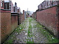
1
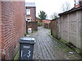
Back Lane off Salford Street Oldham
The old cobbled access lanes are a common sight around the Oldham area
Image: © Paul Anderson
Taken: 6 Jan 2007
0.05 miles
3
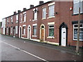
Salford Street Glodwick Oldham
A row of terraced houses which are a familiar sight around the Oldham area
Image: © Paul Anderson
Taken: 6 Jan 2007
0.05 miles
4
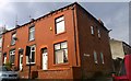
Corner of Roundthorn and Chatsworth Roads
Red-brick terraced houses at the corner of Roundthorn Road and Chatsworth Road, in the Clarksfield area of Oldham, Greater Manchester.
Image: © Steven Haslington
Taken: 11 Apr 2016
0.06 miles
5
New Earth Street, Glodwick
This is the bottom end of New Earth Street near where it meets Roundthorn Road. On the far side of Roundthorn Road is Aspull Street. Glodwick has a high Asian population.
Image: © michael ely
Taken: 21 Mar 2011
0.09 miles
6
Balti House, Glodwick
The Roundthorn Balti House is on Roundthorn Road almost opposite the junction with Cranbrook Street. Glodwick has a high Asian population.
Image: © michael ely
Taken: 21 Mar 2011
0.14 miles
7
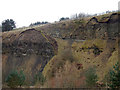
Quarry face , Glodwick Lows
This area was the site of a colliery and brickworks. Rocks are Carboniferous with abundant fossil shells.
Image: © Stephen Darlington
Taken: 24 Feb 2015
0.17 miles
8
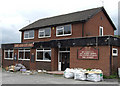
Live and Let Live
Now derelict following the part it played as the epicentre of the Oldham race riots of 2001. Situated on the corner of Glodwick Road and Gartside Street.
Image: © michael ely
Taken: 25 Aug 2008
0.20 miles
9
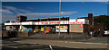
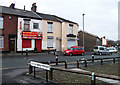
Worldwide
The Oldham branch of the Worldwide supermarket.
Image: © Peter McDermott
Taken: 2 Jul 2017
0.21 miles
10
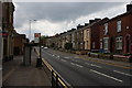
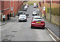
Abbey Hills Road
Heading towards the centre of Oldham.
Image: © Bill Boaden
Taken: 24 Jun 2014
0.22 miles