IMAGES TAKEN NEAR TO
Forge Industrial Estate, Greenacres Road, OLDHAM, OL4 1LE
Introduction
This page details the photographs taken nearby to Forge Industrial Estate, Greenacres Road, OL4 1LE by members of the Geograph project.
The Geograph project started in 2005 with the aim of publishing, organising and preserving representative images for every square kilometre of Great Britain, Ireland and the Isle of Man.

There are currently over 7.5m images from over14,400 individuals and you can help contribute to the project by visiting https://www.geograph.org.uk
Image Map
Images are licensed for reuse under creativecommons.org/licenses/by-sa/2.0
Notes
- Clicking on the map will re-center to the selected point.
- The higher the marker number, the further away the image location is from the centre of the postcode.
Image Listing (42 Images Found)
Images are licensed for reuse under creativecommons.org/licenses/by-sa/2.0
Image
Details
Distance
1
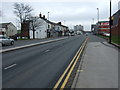
Huddersfield Road (A62), Oldham
Heading north east.
Image: © JThomas
Taken: 14 Mar 2015
0.07 miles
3
Huddersfield Road
Buildings alongside Huddersfield Road in Oldham.
Image: © Peter McDermott
Taken: 2 Jul 2017
0.08 miles
4
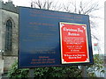
The Parish Church of St James, Oldham, Nameboard
Image: © Alexander P Kapp
Taken: 18 Dec 2012
0.08 miles
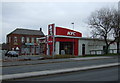
5

Supermarket service station off Huddersfield Road
St James' Church behind.
Image: © JThomas
Taken: 14 Mar 2015
0.08 miles

7
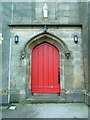
The Parish Church of St James, Oldham, Doorway
Image: © Alexander P Kapp
Taken: 18 Dec 2012
0.09 miles
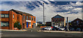
8
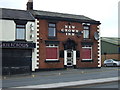
New Crown Inn, Oldham
On Huddersfield Road.
Image: © JThomas
Taken: 14 Mar 2015
0.10 miles
9
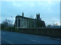
The Parish Church of St James, Oldham
Image: © Alexander P Kapp
Taken: 18 Dec 2012
0.10 miles
10
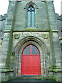
The Parish Church of St James, Oldham, Doorway
Image: © Alexander P Kapp
Taken: 18 Dec 2012
0.10 miles