IMAGES TAKEN NEAR TO
Lees Road, OLDHAM, OL4 1JP
Introduction
This page details the photographs taken nearby to Lees Road, OL4 1JP by members of the Geograph project.
The Geograph project started in 2005 with the aim of publishing, organising and preserving representative images for every square kilometre of Great Britain, Ireland and the Isle of Man.

There are currently over 7.5m images from over14,400 individuals and you can help contribute to the project by visiting https://www.geograph.org.uk
Image Map
Images are licensed for reuse under creativecommons.org/licenses/by-sa/2.0
Notes
- Clicking on the map will re-center to the selected point.
- The higher the marker number, the further away the image location is from the centre of the postcode.
Image Listing (23 Images Found)
Images are licensed for reuse under creativecommons.org/licenses/by-sa/2.0
Image
Details
Distance

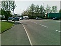
4
Lees Road, Clarksfield
The A669 approaching the junction with Balfour Street.
Image: © Gerald England
Taken: 3 Jul 2013
0.07 miles

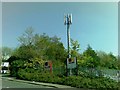
6

The Bridge Inn, Moorhey Street, Oldham
Image: © Alexander P Kapp
Taken: 22 Nov 2012
0.09 miles
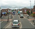
8
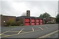
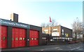
Oldham fire station
Oldham fire station, Lees Road, Oldham, Greater Manchester
Image: © Kevin Hale
Taken: 31 Oct 2007
0.11 miles
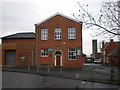
10
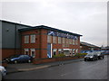
g. r. labels 4 signs
Works on the Mount Pleasant Trading Estate, Oldham
Image: © Alexander P Kapp
Taken: 30 Jan 2009
0.12 miles