IMAGES TAKEN NEAR TO
Burn Bank, OLDHAM, OL3 7LT
Introduction
This page details the photographs taken nearby to Burn Bank, OL3 7LT by members of the Geograph project.
The Geograph project started in 2005 with the aim of publishing, organising and preserving representative images for every square kilometre of Great Britain, Ireland and the Isle of Man.

There are currently over 7.5m images from over14,400 individuals and you can help contribute to the project by visiting https://www.geograph.org.uk
Image Map (Loading...)


Getting Data...Please wait
Leaflet Map data © OpenStreetMap
Images are licensed for reuse under creativecommons.org/licenses/by-sa/2.0
Notes
- Clicking on the map will re-center to the selected point.
- The higher the marker number, the further away the image location is from the centre of the postcode.
Image Listing (69 Images Found)
Images are licensed for reuse under creativecommons.org/licenses/by-sa/2.0
Image
Details
Distance
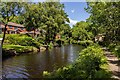
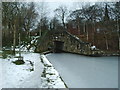
2
The Huddersfield Narrow Canal
View west from the bridge on Well-I-Hole Road.
Image: © JThomas
Taken: 8 Nov 2018
0.03 miles
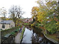
4
Looking towards Well-i'-hole Bridge
From Huddersfield Narrow Canal towpath
Image: © Chris Morgan
Taken: 18 Mar 2019
0.04 miles
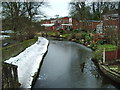
5
Bridge which carries the B6175 over the Huddersfield Narrow Canal
Image: © Alexander P Kapp
Taken: 12 Feb 2009
0.05 miles
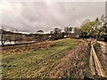
6
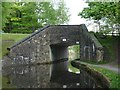
Manns Wharf Bridge
This has the square profile of a rebuilt bridge.
Image: © Christine Johnstone
Taken: 18 May 2010
0.05 miles
7
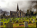
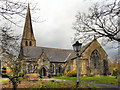
Christ Church, Friezland
The Parish of Friezland lies at the southern end of the village of Greenfield, Built in 1850, Christ Church, is a Grade II listed building ( http://www.britishlistedbuildings.co.uk/en-212061-christ-church-friezland-saddleworth - British listed buildings).
Image: © David Dixon
Taken: 25 Nov 2011
0.05 miles
8
Christ Church & Graveyard
The Parish of Friezland lies at the southern end of the village of Greenfield, Built in 1850, Christ Church, is a Grade II listed building ( http://www.britishlistedbuildings.co.uk/en-212061-christ-church-friezland-saddleworth - British listed buildings)
Image: © David Dixon
Taken: 25 Nov 2011
0.06 miles
9
Christ Church, Friezland
The Parish of Friezland lies at the southern end of the village of Greenfield, Built in 1850, Christ Church, is a Grade II listed building ( http://www.britishlistedbuildings.co.uk/en-212061-christ-church-friezland-saddleworth - British listed buildings)
Image: © David Dixon
Taken: 25 Nov 2011
0.06 miles
10
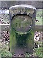
Canal Milemarker by the Huddersfield Narrow Canal, Grasscroft
Milemarker by the Huddersfield Narrow Canal, in parish of Saddleworth (Oldham District), Wellihole Bridge, Grasscroft, near Well Hole Bridge.
Inscription reads:-
14
MILES
Grade II listed.
List Entry Number: 1253529 https://historicengland.org.uk/listing/the-list/list-entry/1253529
To be surveyed
Milestone Society National ID: HUN-14
Image: © Milestone Society
Taken: Unknown
0.06 miles