IMAGES TAKEN NEAR TO
Chew Valley Road, OLDHAM, OL3 7JG
Introduction
This page details the photographs taken nearby to Chew Valley Road, OL3 7JG by members of the Geograph project.
The Geograph project started in 2005 with the aim of publishing, organising and preserving representative images for every square kilometre of Great Britain, Ireland and the Isle of Man.

There are currently over 7.5m images from over14,400 individuals and you can help contribute to the project by visiting https://www.geograph.org.uk
Image Map
Images are licensed for reuse under creativecommons.org/licenses/by-sa/2.0
Notes
- Clicking on the map will re-center to the selected point.
- The higher the marker number, the further away the image location is from the centre of the postcode.
Image Listing (118 Images Found)
Images are licensed for reuse under creativecommons.org/licenses/by-sa/2.0
Image
Details
Distance
1
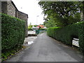
Arthur's Lane, Greenfield
Leading to Higher Arthurs Lane and South Avenue from Chew Valley Road.
Image: © John Topping
Taken: 5 Oct 2013
0.02 miles
2
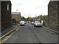
Shaw Street, Greenfield
Leading to South Avenue from Chew Valley Road.
Image: © John Topping
Taken: 5 Oct 2013
0.02 miles
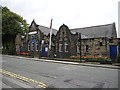
3
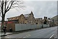
Former Greenfield Conservative Club
Being restored and converted into housing; https://saddind.co.uk/plans-for-historic-conservative-club-to-be-turned-into-houses/
Image: © Chris Morgan
Taken: 18 Mar 2019
0.03 miles
4
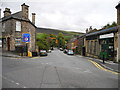
Greenbridge Lane, Greenfield
Viewed from the junction with Chew Valley Road. Alphin Brow (SE0003) in the background.
Image: © John Topping
Taken: 5 Oct 2013
0.03 miles
5
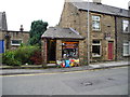
The Saddleworth Coal Hut, Greenfield
Next to Greenfield Conservative Club, on Chew Valley Road. Nice coloured bags, different than the old coal sacks from the 1950/60's.
Image: © John Topping
Taken: 5 Oct 2013
0.04 miles
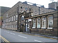
6
Greenfield Conservative Club
Chew Valley Road.
Image: © John Topping
Taken: 5 Oct 2013
0.04 miles
7
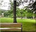
Greenfield Village Green
Off Chew Valley Road.
Image: © Gerald England
Taken: 3 Jul 2013
0.05 miles
8
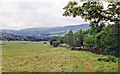
Site of Friezland station, 1996
View northward in the Tame Valley, towards Diggle and Saddleworth Moor. Friezland and the other local stations on the Micklehurst Loop, the relief line between Stalybridge and the Standedge Tunnel at Diggle of the ex-LNWR Manchester Huddersfield - Leeds main line, were closed to passengers back in 1/17, but remained for goods until the loop, having ceased to carry through passenger traffic from 7/9/64, was closed entirely on 27/2/65, having remained busy with freight. The road in the trees on the right may be this former railway.
Image: © Ben Brooksbank
Taken: 13 Jul 1996
0.06 miles
9
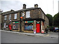
Greenfield Post Office
Corner of Chew Valley Road and Wilson Street.
Image: © John Topping
Taken: 5 Oct 2013
0.06 miles
10
Wellington Mill Greenfield
This old mill, formerly Knoll Spinning, was demolished in April 2010 to make way for a new Tesco store.
Image
http://www.oldham-chronicle.co.uk/news-features/8/news-headlines/40003/iconic-mill-slowly-reduced-to-rubble
Image: © Paul Anderson
Taken: 15 Nov 2006
0.06 miles