IMAGES TAKEN NEAR TO
Boarhurst Farm, OLDHAM, OL3 7EH
Introduction
This page details the photographs taken nearby to Boarhurst Farm, OL3 7EH by members of the Geograph project.
The Geograph project started in 2005 with the aim of publishing, organising and preserving representative images for every square kilometre of Great Britain, Ireland and the Isle of Man.

There are currently over 7.5m images from over14,400 individuals and you can help contribute to the project by visiting https://www.geograph.org.uk
Image Map
Images are licensed for reuse under creativecommons.org/licenses/by-sa/2.0
Notes
- Clicking on the map will re-center to the selected point.
- The higher the marker number, the further away the image location is from the centre of the postcode.
Image Listing (45 Images Found)
Images are licensed for reuse under creativecommons.org/licenses/by-sa/2.0
Image
Details
Distance
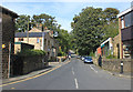
1
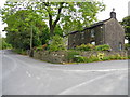
Old School House, Greenfield
Situated on the corner of Boarshurst Lane (L) and Park Lane (R).
Image: © John Topping
Taken: 5 Oct 2013
0.03 miles
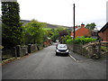
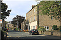
2
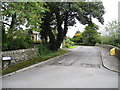
Steadway, Greenfield
Viewed from Park Lane.
Image: © John Topping
Taken: 5 Oct 2013
0.05 miles
3
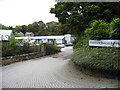
Boarshurst Business Park, Greenfield
Off Boarshurst Lane.
Image: © John Topping
Taken: 5 Oct 2013
0.06 miles
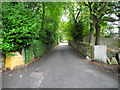
4
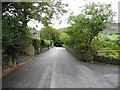
Park Lane, Greenfield
Heading down to Holmfirth Road (A635).
Image: © John Topping
Taken: 5 Oct 2013
0.09 miles
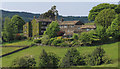
5
Boarshurst
Looking west from Boarshurst Lane, near Greenfield, Saddleworth, towards Higher Kinders, with Wharmton in the background.
Image: © Martin Clark
Taken: Unknown
0.14 miles
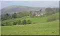
7
Higher Kinders from Boarshurst
A classic farmer-weavers' hamlet.
Image: © Michael Fox
Taken: 23 May 2010
0.14 miles
9
Kinders Lane, Greenfield
Viewed from Road End in the centre of the village, Kinders Lane is likely to be on the line of a very old trackway from Cheshire to the Standedge ridge above Diggle.
Image: © Michael Fox
Taken: 27 Sep 2011
0.15 miles
10
Chew Valley Road, Greenfield
The three-storey building, which dates from the late nineteenth century, was the hall of the erstwhile Greenfield Co-operative Society.
Image: © Michael Fox
Taken: 27 Sep 2011
0.16 miles