IMAGES TAKEN NEAR TO
Manchester Road, OLDHAM, OL3 7DW
Introduction
This page details the photographs taken nearby to Manchester Road, OL3 7DW by members of the Geograph project.
The Geograph project started in 2005 with the aim of publishing, organising and preserving representative images for every square kilometre of Great Britain, Ireland and the Isle of Man.

There are currently over 7.5m images from over14,400 individuals and you can help contribute to the project by visiting https://www.geograph.org.uk
Image Map (Loading...)


Getting Data...Please wait
Leaflet Map data © OpenStreetMap
Images are licensed for reuse under creativecommons.org/licenses/by-sa/2.0
Notes
- Clicking on the map will re-center to the selected point.
- The higher the marker number, the further away the image location is from the centre of the postcode.
Image Listing (52 Images Found)
Images are licensed for reuse under creativecommons.org/licenses/by-sa/2.0
Image
Details
Distance
1
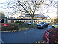
St. Mary's CE Primary School, Greenfield
On Manchester Road (A635).
Image: © JThomas
Taken: 15 Nov 2018
0.02 miles
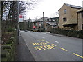
3
Manchester Road (A635), Geenfield
Looking east.
Image: © JThomas
Taken: 15 Nov 2018
0.03 miles
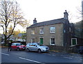
4
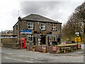
Clarence Hotel
The traffic island in front of the Clarence is also used as a terminus for buses from Manchester and Oldham.
Image
The new build to the right used to be the local petrol station.
Image: © Paul Anderson
Taken: 18 Dec 2006
0.04 miles
5
Clarence Hotel Greenfield
This is the terminus for buses from Manchester and Oldham see also
Image
Image: © Paul Anderson
Taken: 18 Dec 2006
0.04 miles
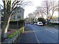
6
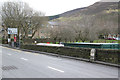
Chew Valley Road, Greenfield
General view with the milestone shown in http://www.geograph.org.uk/photo/3807701 .
Image: © Alan Murray-Rust
Taken: 7 Jan 2014
0.05 miles
7
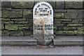
Milestone on Chew Valley Road, Greenfield
Cast iron turnpike milestone attached to a stone pillar. See http://www.geograph.org.uk/photo/3807703
Image: © Alan Murray-Rust
Taken: 7 Jan 2014
0.06 miles
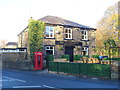
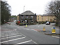
9
The Clarence Hotel, Greenfield
The Clarence Hotel is at the junction of Manchester Road/Holmfirth Road (A635) with Chew Valley Road (A669).
Image: © David Dixon
Taken: 17 Mar 2013
0.06 miles
10
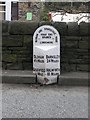
Old Milestone by the A669, Chew Valley Road, Greenfield, Saddleworth parish
Metal plate attached to stone post by the A669, in parish of SADDLEWORTH (OLDHAM District), Greenfield, Chew Valley Road, 100m West of Clarence Hotel, by wall 300m West of A635, on South side of road, in front of school wall. Erected by the County Council in the 19th/20th century.
Inscription reads:-
: OLDHAM / 4¾ MILES / GREENFIELD / ½ MILE : : OLDHAM & STANDEDGE ROAD / ROAD END / BRANCH / LORDSMERE : : BARNSLEY / 24 MILES / HOLMFIRTH / 10 MILES :
Milestone Society National ID: YW_ODSD04a.
Image: © C Minto
Taken: 25 Sep 2002
0.07 miles