IMAGES TAKEN NEAR TO
Carr Lane, OLDHAM, OL3 7AZ
Introduction
This page details the photographs taken nearby to Carr Lane, OL3 7AZ by members of the Geograph project.
The Geograph project started in 2005 with the aim of publishing, organising and preserving representative images for every square kilometre of Great Britain, Ireland and the Isle of Man.

There are currently over 7.5m images from over14,400 individuals and you can help contribute to the project by visiting https://www.geograph.org.uk
Image Map (63 Images)


Leaflet Map data © OpenStreetMap
Images are licensed for reuse under creativecommons.org/licenses/by-sa/2.0
Notes
- Clicking on the map will re-center to the selected point.
- The higher the marker number, the further away the image location is from the centre of the postcode.
Image Listing (63 Images Found)
Images are licensed for reuse under creativecommons.org/licenses/by-sa/2.0
Image
Details
Distance
1
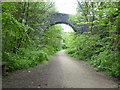
The Pennine Bridleway near Lower Arthurs
Image: © Dave Kelly
Taken: 28 May 2019
0.07 miles
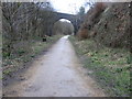
3
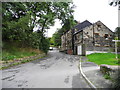
Route of former railway at Lower Arthurs
Now a multi-purpose route used by the Tame Valley Way
Image: © Kevin Waterhouse
Taken: 19 Mar 2023
0.09 miles
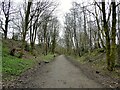
4
South Avenue, Greenfield
Viewed from Arthur's Lane.
Image: © John Topping
Taken: 5 Oct 2013
0.12 miles
5

Beech Avenue
Off Carr Lane between Greenfield and Uppermill.
Image: © Gerald England
Taken: 3 Jul 2013
0.12 miles
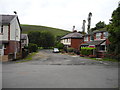
6
Higher Arthur's, Greenfield
Leading to Kinders Lane from Arthur's Lane.
Image: © John Topping
Taken: 5 Oct 2013
0.14 miles
7
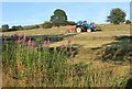
Summer evening, Greenfield
Looking towards Pots and Pans from just above Carr Lane.
Image: © Michael Fox
Taken: 29 Jul 2011
0.16 miles
8
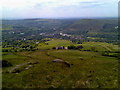
View SW from War Memorial over Greenfield
Image: © Brendan Greenwood
Taken: Unknown
0.16 miles
9

85 Beech Avenue, Greenfield
Suburban homes on Beech Avenue in the Greenfield area of Saddleworth, Greater Manchester, England.
Image: © Steven Haslington
Taken: 19 Mar 2015
0.16 miles
10
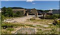
Lower Arthurs
Development site in Lower Arthurs.
Image: © Peter McDermott
Taken: 2 Jul 2017
0.17 miles