IMAGES TAKEN NEAR TO
Wellington Road, OLDHAM, OL3 7AL
Introduction
This page details the photographs taken nearby to Wellington Road, OL3 7AL by members of the Geograph project.
The Geograph project started in 2005 with the aim of publishing, organising and preserving representative images for every square kilometre of Great Britain, Ireland and the Isle of Man.

There are currently over 7.5m images from over14,400 individuals and you can help contribute to the project by visiting https://www.geograph.org.uk
Image Map (Loading...)


Getting Data...Please wait
Leaflet Map data © OpenStreetMap
Images are licensed for reuse under creativecommons.org/licenses/by-sa/2.0
Notes
- Clicking on the map will re-center to the selected point.
- The higher the marker number, the further away the image location is from the centre of the postcode.
Image Listing (60 Images Found)
Images are licensed for reuse under creativecommons.org/licenses/by-sa/2.0
Image
Details
Distance
1
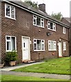
Beech Avenue
Off Carr Lane between Greenfield and Uppermill.
Image: © Gerald England
Taken: 3 Jul 2013
0.05 miles
2
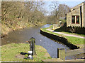
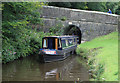
Lock 20 on the Huddersfield Canal, near Greenfield
Looking north towards Uppermill from Lock 20, Huddersfield Narrow Canal, near Greenfield.
Image: © Martin Clark
Taken: Unknown
0.05 miles
3
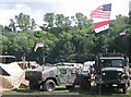
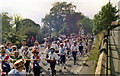
Saddleworth Wartime Weekend 2008
On the second weekend of August every year there is a wartime weekend event in Saddleworth http://www.yanksarebackinsaddleworth.co.uk/
Over the weekend there are various events throughout the area with a huge encampment on the Churchill playing fields above.
On the Sunday one of the biggest convoys of wartime vehicles makes its away around Saddleworth passing through
the villages of Uppermill, Delph, Standedge, Diggle, Dobcross and back to Uppermill.
If the weather is good the event brings the crowds and their cameras out who line the route through the all villages.
Image
Image
Image
Image
Image
Image
Image: © Paul Anderson
Taken: 10 Aug 2008
0.06 miles
4
Lock 20W on the Huddersfield Narrow Canal
Approaching Greenfield.
Image: © michael ely
Taken: 13 Jan 2015
0.07 miles
5
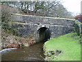
Huddersfield Narrow Canal, Bridge 79
After being derelict for 50 years the canal reopened to narrow boats (up to 6' 10") in 2001.
Image: © Peter Holmes
Taken: 5 Feb 2011
0.08 miles
6
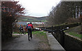
Huddersfield Narrow Canal, Lock 20W
Public footpath to Frenches Bridge. After being derelict for 50 years the canal reopened to narrow boats (up to 6' 10") in 2001.
Image: © Peter Holmes
Taken: 5 Feb 2011
0.09 miles
7
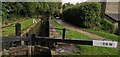
Lock 20W on Huddersfield Narrow Canal at Greenfield
Lock gates replaced 2013.
Image: © Chris Morgan
Taken: 23 Sep 2019
0.09 miles
8
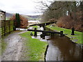
Halls Lock. Huddersfield Canal, Greenfield
This section was restored to use in 2001.
Image: © Michael Fox
Taken: 6 Aug 2011
0.10 miles
9
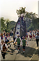
Saddleworth Rushcart Festival 1976
The rushcart is being pulled up Chapel Road, towards Oldham Road and Uppermill High Street.
Image: © David Dixon
Taken: 21 Aug 1976
0.11 miles
10
Saddleworth Rushcart 1976
The cart, being drawn up Chapel Road, towards the junction with Oldham Road.
Image: © David Dixon
Taken: 21 Aug 1976
0.11 miles