IMAGES TAKEN NEAR TO
Settstones Lane, OLDHAM, OL3 6LL
Introduction
This page details the photographs taken nearby to Settstones Lane, OL3 6LL by members of the Geograph project.
The Geograph project started in 2005 with the aim of publishing, organising and preserving representative images for every square kilometre of Great Britain, Ireland and the Isle of Man.

There are currently over 7.5m images from over14,400 individuals and you can help contribute to the project by visiting https://www.geograph.org.uk
Image Map (Loading...)


Getting Data...Please wait
Leaflet Map data © OpenStreetMap
Images are licensed for reuse under creativecommons.org/licenses/by-sa/2.0
Notes
- Clicking on the map will re-center to the selected point.
- The higher the marker number, the further away the image location is from the centre of the postcode.
Image Listing (43 Images Found)
Images are licensed for reuse under creativecommons.org/licenses/by-sa/2.0
Image
Details
Distance
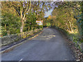
2
The Cross Keys, Uppermill
Hyde's pub situated quite a long way above Uppermill. It also provides a base for the local Mountain Rescue team.
Image: © Bill Boaden
Taken: 20 Apr 2013
0.07 miles
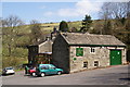
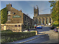
3
Cross Keys Inn Uppermill
Built originally in 1745, and situated on the old Marsden packhorse
route, the Cross Keys Inn is located just off Church Road to the east of Uppermill.
It first opened as a tavern back in 1763 and today the pub is owned by J.W.Lees Brewery http://www.jwlees.co.uk/index2.php
The pub is a popular stop off for dog walkers, hikers and mountain bikers.
The building on the right with the green doors is called the barn
which is the home of the Oldham Mountain Rescue Team which was formed in 1964
and is just one of around 53 teams of volunteers providing a search and rescue
service prepared to help people in difficulties
in the wild and remote places of the UK.
In 2008 the Oldham Mountain Rescue Team had 44 callouts
to help 41 casualties which needed 1,778 man hours of rescue activity http://www.omrt.org/Welcome.html
Image: © Paul Anderson
Taken: 22 Feb 2009
0.07 miles
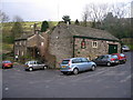
4
Behind the Cross Keys
A path coming down behind the pub.
Image: © John Illingworth
Taken: 13 Jul 2011
0.09 miles
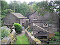
6

Lode Clough from Runninghill Gate
An old hillside farmstead, probably dating from the eighteenth century.
Image: © Michael Fox
Taken: 26 Jun 2011
0.10 miles
7
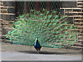
Peacock in front of the Church Inn Uppermill
This peacock shows off his plumage outside the Church Inn public house in Saddleworth
Image
Image: © Paul Anderson
Taken: 26 Apr 2008
0.11 miles
8
Gravestone
For the Hirst family, in St Chad's graveyard
Image: © Alexander P Kapp
Taken: 28 Jun 2007
0.11 miles
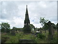
9
The Church Inn and St Chad's Church, Saddleworth
Saddleworth Parish Church, seen here behind the adjacent Church Inn, was founded around 1200 Its tower was rebuilt in 1746 and the body was enlarged and mostly rebuilt in 1832-3. It is a Grade II listed building.
Image: © David Dixon
Taken: 28 Oct 2011
0.11 miles
10
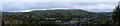
Saddleworth Moor and Uppermill
A Panorama taken from Saddlweorth Golf Club across the valley of the Tame, and the village of Uppermill, looking on toward Saddleworth Moor
This is a panorama stitched from four images of 6000x4000 pixels, giving a final size of 16108x 3508 pixels, using Microsoft's ICE. This was then reduced down to 7249 x 1579 pixels to fit Geograph's upload limits. The larger version will be available on request.
See Image for a comparison piece made in-camera
Image: © Bob Harvey
Taken: 13 Oct 2017
0.12 miles