IMAGES TAKEN NEAR TO
Slackgate Lane, OLDHAM, OL3 5TZ
Introduction
This page details the photographs taken nearby to Slackgate Lane, OL3 5TZ by members of the Geograph project.
The Geograph project started in 2005 with the aim of publishing, organising and preserving representative images for every square kilometre of Great Britain, Ireland and the Isle of Man.

There are currently over 7.5m images from over14,400 individuals and you can help contribute to the project by visiting https://www.geograph.org.uk
Image Map
Images are licensed for reuse under creativecommons.org/licenses/by-sa/2.0
Notes
- Clicking on the map will re-center to the selected point.
- The higher the marker number, the further away the image location is from the centre of the postcode.
Image Listing (13 Images Found)
Images are licensed for reuse under creativecommons.org/licenses/by-sa/2.0
Image
Details
Distance
6
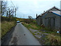
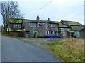
Disused Farm Buildings
These disused farm buildings on Slack Gate Lane are in a poor state
with trees growing on the inside of the out building on the right.
Image
Image: © Paul Anderson
Taken: 26 Jul 2007
0.19 miles
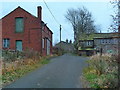
7
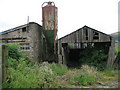
Old Farm
This old disused farm is on Slack Gate Lane close to the hamlet of Slackcote.
Image
Image: © Paul Anderson
Taken: 26 Jul 2007
0.20 miles
9
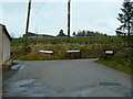
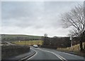
Junction of Wham Lane with Ox Hey Lane and Slackgate Lane
Image: © Alexander P Kapp
Taken: 14 Nov 2012
0.21 miles
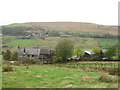
10
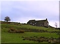
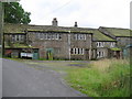
Tame Valley at Denshaw 2
A view of Higher Slack Farm from Slack Gate Lane between Denshaw and Delph.
Image: © Bobby Clegg
Taken: 15 Jan 2015
0.22 miles