IMAGES TAKEN NEAR TO
Heights Lane, OLDHAM, OL3 5TU
Introduction
This page details the photographs taken nearby to Heights Lane, OL3 5TU by members of the Geograph project.
The Geograph project started in 2005 with the aim of publishing, organising and preserving representative images for every square kilometre of Great Britain, Ireland and the Isle of Man.

There are currently over 7.5m images from over14,400 individuals and you can help contribute to the project by visiting https://www.geograph.org.uk
Image Map (Loading...)


Getting Data...Please wait
Leaflet Map data © OpenStreetMap
Images are licensed for reuse under creativecommons.org/licenses/by-sa/2.0
Notes
- Clicking on the map will re-center to the selected point.
- The higher the marker number, the further away the image location is from the centre of the postcode.
Image Listing (41 Images Found)
Images are licensed for reuse under creativecommons.org/licenses/by-sa/2.0
Image
Details
Distance
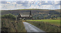
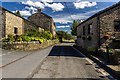
1
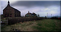
Chapel and pub above Delph
A wonderful pair of buildings in a dramatic setting overlooking the Tame Valley.
The pub Image is only open in the evenings during the week (check in TGBG) but makes a great rest-point for Sunday afternoon walks. (Sun:12-5 7-10:30)
Image: © Howard Selina
Taken: Unknown
0.06 miles
2
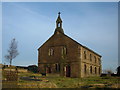
St Thomas Friarmere church above Delph
This church is no longer in use as a place of worship but is cared for by The Churches Conservation Trust as part of the nation's heritage.
Image: © michael ely
Taken: 21 Nov 2005
0.06 miles
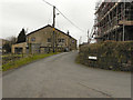
3
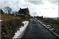
Springhead Cottage, Heights Lane, Delph
One of a few isolated houses on a very narrow road above the Saddleworth village of Delph.
Image: © michael ely
Taken: 27 Jan 2013
0.06 miles
4
Delph, churchyard
At St. Thomas Old Church Image
Image: © Mike Faherty
Taken: 22 Jan 2017
0.06 miles
5
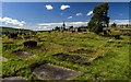
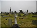
Graveyard
The Graveyard at St Thomas' Church.
Image: © Peter McDermott
Taken: 2 Jul 2017
0.07 miles
7
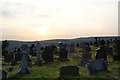
Graveyard of St Thomas, Friarmere
This is facing towards the setting sun and the hills on the other side of the Tame valley.
Image: © Bill Boaden
Taken: 1 Sep 2010
0.08 miles
10
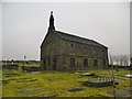
Delph, Heights Chapel
Formally St. Thomas Old Church, Friarmere, but now redundant. Overlooking moorland, and opposite Image on Broad Lane. Dated from 1765, and listed by Historic England: http://www.imagesofengland.org.uk/Details/Default.aspx?id=212027&mode=adv
Image: © Mike Faherty
Taken: 22 Jan 2017
0.09 miles