IMAGES TAKEN NEAR TO
Oldham Road, OLDHAM, OL3 5RP
Introduction
This page details the photographs taken nearby to Oldham Road, OL3 5RP by members of the Geograph project.
The Geograph project started in 2005 with the aim of publishing, organising and preserving representative images for every square kilometre of Great Britain, Ireland and the Isle of Man.

There are currently over 7.5m images from over14,400 individuals and you can help contribute to the project by visiting https://www.geograph.org.uk
Image Map (Loading...)


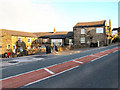
Getting Data...Please wait
Leaflet Map data © OpenStreetMap
Images are licensed for reuse under creativecommons.org/licenses/by-sa/2.0
Notes
- Clicking on the map will re-center to the selected point.
- The higher the marker number, the further away the image location is from the centre of the postcode.
Image Listing (18 Images Found)
Images are licensed for reuse under creativecommons.org/licenses/by-sa/2.0
Image
Details
Distance
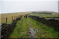
1
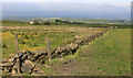
Mantley from near Mantley Gate
Despite the abandoned field at left, much of this area, located about 1,000' above sea level, is still used for grazing.
Image: © Michael Fox
Taken: 4 Jun 2011
0.14 miles
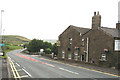
2
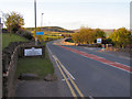
A672 Entering Yorkshire
Oldham Road (A672) at Grains Bar; the boundary between Lancashire and Yorkshire.
Image: © David Dixon
Taken: 12 May 2010
0.15 miles
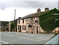
3

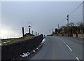
Oldham Road
Oldham Road (A672) at Grains Bar.
Image: © David Dixon
Taken: 12 May 2010
0.15 miles
5
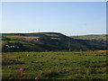
A wet day on the Crompton Circuit
A very pleasant path on a dry day, with views to the right over Denshaw and the Tame valley, and to the left over Oldham.
Image: © Bill Boaden
Taken: 16 Jul 2011
0.20 miles
6
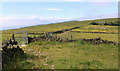
Upland spring afternoon
The path from Grains Bar to the 'Moorcock'runs from left to right towards the house called Mantley. This path marks the north western boundary of Saddleworth.
Image: © Michael Fox
Taken: 4 Jun 2011
0.23 miles
7
Grains Bar
Looking northeast from this five-way crossroads, along the A672 into Yorkshire.
Oldham Corporation electric trams formerly reached this point, probably the highest ever reached by a conventional passenger tramway in mainland Britain.
Image: © Dr Neil Clifton
Taken: 4 Aug 2010
0.23 miles
9
Shaw and Crompton Parish Boundary at Grains Bar
The metal boundary plaque can be seen on the left hand side of the road. View looking northwest along the B6197, Buckstones Road, at Grains Bar. A close-up of the plaque can be seen here Image
Image: © michael ely
Taken: 24 Mar 2008
0.24 miles