IMAGES TAKEN NEAR TO
Husteads, OLDHAM, OL3 5RA
Introduction
This page details the photographs taken nearby to Husteads, OL3 5RA by members of the Geograph project.
The Geograph project started in 2005 with the aim of publishing, organising and preserving representative images for every square kilometre of Great Britain, Ireland and the Isle of Man.

There are currently over 7.5m images from over14,400 individuals and you can help contribute to the project by visiting https://www.geograph.org.uk
Image Map
Images are licensed for reuse under creativecommons.org/licenses/by-sa/2.0
Notes
- Clicking on the map will re-center to the selected point.
- The higher the marker number, the further away the image location is from the centre of the postcode.
Image Listing (19 Images Found)
Images are licensed for reuse under creativecommons.org/licenses/by-sa/2.0
Image
Details
Distance
1
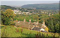
Husteads, looking east towards Dobcross village.
The photograph was taken from the steps on the path between Broadgate and Husteads Lane.
Image: © Michael Fox
Taken: 9 Sep 2014
0.01 miles
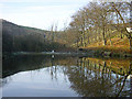
2
Wall Hill Brook Reservoir near Dobcross
Image: © John Slater
Taken: 10 Oct 2015
0.06 miles
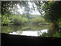
3
Wall Hill Brook Reservoir, Dobcross
The small reservoir on the Wall Hill Brook, west of the village of Dobcross, near Oldham.
Image: © Martin Clark
Taken: Unknown
0.07 miles
4
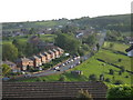
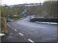
Wall Hill Road Dobcross
The red-brick semi-detached houses seen in the picture are on Wall Hill Road.
This road links the A62 at the top of the hill with the A6052 in the bottom of the valley.
Image
Image: © Paul Anderson
Taken: 2 Jun 2007
0.16 miles
5
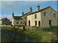
Mount Sorrel Farm
Recently a derelict farm now brought back to life
Image: © Geoff Hope
Taken: 20 Aug 2008
0.17 miles
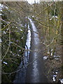
7
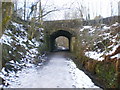
Cycling along the Delph Donkey
A recreational route along the line of a former railway line. The bridge carries Wall Hill Road over the trail near Dobcross.
Image: © michael ely
Taken: 10 Feb 2013
0.20 miles
9
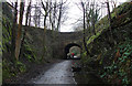
The Delph Donkey
The name was given when this was a railway line between Delph and Uppermills, the line was opened in 1851 and some of the early services were provided by horse drawn waggons until the steam engines arrived and with that the locals nicknamed the line The Delph Donkey, the name has stuck. http://www.geograph.org.uk/photo/1164483
Image: © Alexander P Kapp
Taken: 13 Feb 2009
0.21 miles
10
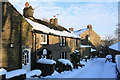
Tamewater hamlet
The datestone '1725' attests to the antiquity of this location.
Image: © Michael Fox
Taken: 9 Jan 2010
0.22 miles