IMAGES TAKEN NEAR TO
Standedge, OLDHAM, OL3 5LU
Introduction
This page details the photographs taken nearby to Standedge, OL3 5LU by members of the Geograph project.
The Geograph project started in 2005 with the aim of publishing, organising and preserving representative images for every square kilometre of Great Britain, Ireland and the Isle of Man.

There are currently over 7.5m images from over14,400 individuals and you can help contribute to the project by visiting https://www.geograph.org.uk
Image Map
Images are licensed for reuse under creativecommons.org/licenses/by-sa/2.0
Notes
- Clicking on the map will re-center to the selected point.
- The higher the marker number, the further away the image location is from the centre of the postcode.
Image Listing (22 Images Found)
Images are licensed for reuse under creativecommons.org/licenses/by-sa/2.0
Image
Details
Distance
1
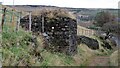
World War II Pillbox
A well disguised strong point overlooking the A62
Image: © Kevin Waterhouse
Taken: 27 Nov 2020
0.04 miles
2
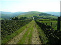
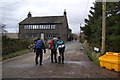
Standedge Trail heading towards Bleak Hey Nook
Image: © John H Darch
Taken: 12 Sep 2009
0.04 miles
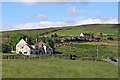
3
Cows still in mud
One of the cows away from the main group appeared to have very short legs. We realised that that was because it was standing in deep mud.
Image: © John Illingworth
Taken: 9 Feb 2011
0.05 miles
4
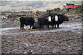
Cows in mud
We weren't impressed by the conditions these cows were existing in.
Image: © Bill Boaden
Taken: 27 Mar 2010
0.05 miles
5
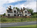
Horse and Jockey
Once a thriving public house at the junction of the main A62 and A670 The Horse and Jockey is now just a derelict shell.
After being empty for many years the former pub has gradually deteriorated into its present state.
Image: © Paul Anderson
Taken: 1 Jul 2007
0.09 miles
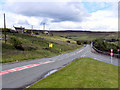
7
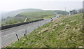
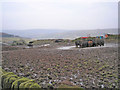
Bleak Hey Nook
The junction of the A62 and A670 at Bleak Hey Nook, high in the Pennines to the east of Oldham.
Image: © Martin Clark
Taken: Unknown
0.10 miles
8
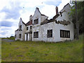
Horse and Jockey
The Horse and Jockey, which stood at the junction of Huddersfield Road and Standedge Road was a thriving pub in the 1950s and 1960s, when the A62 was one of the busiest routes across the Pennines. However, trade dwindled after the construction of the M62 motorway and this derelict shell is all that remains
Image: © David Dixon
Taken: 16 Jun 2011
0.10 miles
9
A62/A670 Junction
The junction of Huddersfield Road (A62) and Standedge Road (A670).
Image: © David Dixon
Taken: 16 Jun 2011
0.10 miles
10
The 'Horse and Jockey' public house
Closed around 1992, this pub was gutted by fire some years later. For some reason it has neither been restored nor demolished.
Image: © Michael Fox
Taken: 12 Jun 2010
0.11 miles