IMAGES TAKEN NEAR TO
Diggle Mill Cottages, OLDHAM, OL3 5LH
Introduction
This page details the photographs taken nearby to Diggle Mill Cottages, OL3 5LH by members of the Geograph project.
The Geograph project started in 2005 with the aim of publishing, organising and preserving representative images for every square kilometre of Great Britain, Ireland and the Isle of Man.

There are currently over 7.5m images from over14,400 individuals and you can help contribute to the project by visiting https://www.geograph.org.uk
Image Map (Loading...)


Getting Data...Please wait
Leaflet Map data © OpenStreetMap
Images are licensed for reuse under creativecommons.org/licenses/by-sa/2.0
Notes
- Clicking on the map will re-center to the selected point.
- The higher the marker number, the further away the image location is from the centre of the postcode.
Image Listing (4 Images Found)
Images are licensed for reuse under creativecommons.org/licenses/by-sa/2.0
Image
Details
Distance
1
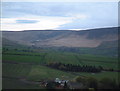
Upper Diggle Valley from Carr House
Saddleworth Moor and Rifle Range looking East
Image: © Colin Berry
Taken: 22 Apr 2002
0.18 miles
2
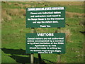
You have been told!
The sign says it all.
Continue along this lane at your peril.
Image: © Paul Anderson
Taken: 29 Oct 2006
0.19 miles
3
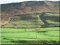
Ravenstone Rocks
Very little to photograph in this square located near Diggle.
Along the top is Ravenstone Rocks with a small waterfall running down the right of the picture.
Image: © Paul Anderson
Taken: 29 Oct 2006
0.22 miles
4
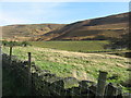
Diggle reservoir and Rifle Range
If you look closely you can see the rifle range at the base of the reservoir; this is as close as I could get. Look at Image
Image: © Paul Anderson
Taken: 29 Oct 2006
0.22 miles