IMAGES TAKEN NEAR TO
Brookside Terrace, OLDHAM, OL3 5EW
Introduction
This page details the photographs taken nearby to Brookside Terrace, OL3 5EW by members of the Geograph project.
The Geograph project started in 2005 with the aim of publishing, organising and preserving representative images for every square kilometre of Great Britain, Ireland and the Isle of Man.

There are currently over 7.5m images from over14,400 individuals and you can help contribute to the project by visiting https://www.geograph.org.uk
Image Map (Loading...)


Getting Data...Please wait
Leaflet Map data © OpenStreetMap
Images are licensed for reuse under creativecommons.org/licenses/by-sa/2.0
Notes
- Clicking on the map will re-center to the selected point.
- The higher the marker number, the further away the image location is from the centre of the postcode.
Image Listing (99 Images Found)
Images are licensed for reuse under creativecommons.org/licenses/by-sa/2.0
Image
Details
Distance
1
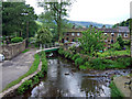
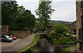
Down by the river
View from King street...Delph
Image: © Bob Abell
Taken: 23 Jun 2009
0.02 miles
2
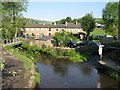
River Tame Delph
The River Tame is seen here from Delph Bridge as it passes close to the village centre.
Image: © Paul Anderson
Taken: 2 Jun 2007
0.02 miles
3
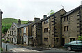
9-11 High Street, Delph
The angled houses on the right are described in the listing as late C18th, making them distinctly old-fashioned. Grade II listed.
Image: © Stephen Richards
Taken: 13 Jun 2016
0.03 miles
4
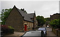
Delph Methodist Church
This looks like it used to be a school building.
Image: © Bill Boaden
Taken: 28 Jun 2010
0.03 miles
5
The River Tame at Delph
Viewed from High Street bridge. The graves on the left are at the back of the Methodist Church.
Image: © Bill Boaden
Taken: 28 Jun 2010
0.03 miles
6
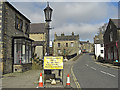
High Street, Delph
Looking towards the bridge over the River Tame. In 2007 the bridge was closed for major repairs - see here http://www.geograph.org.uk/photo/511330.
Image: © michael ely
Taken: 17 Mar 2009
0.03 miles
7
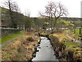
River Tame, Delph
Looking upstream from the bank, behind Gartside Street
Image: © David Dixon
Taken: 3 Feb 2011
0.03 miles
8
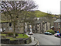
High Street, Delph
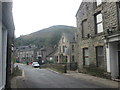
The northern end of High Street, as it enters Delph village. The skyline is dominated by the nearby Knott Hill.
Image: © David Dixon
Taken: 3 Feb 2011
0.03 miles
10
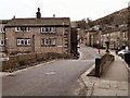
Delph Bridge (High Street)
A view across the Grade II listed, 18th century humped bridge across the River Tame at Delph. The footway on the right hand side is a twentieth century addition, made necessary by the increased vehicular traffic on High Street.
Image: © David Dixon
Taken: 3 Feb 2011
0.03 miles