IMAGES TAKEN NEAR TO
Stoneswood Road, OLDHAM, OL3 5DY
Introduction
This page details the photographs taken nearby to Stoneswood Road, OL3 5DY by members of the Geograph project.
The Geograph project started in 2005 with the aim of publishing, organising and preserving representative images for every square kilometre of Great Britain, Ireland and the Isle of Man.

There are currently over 7.5m images from over14,400 individuals and you can help contribute to the project by visiting https://www.geograph.org.uk
Image Map
Images are licensed for reuse under creativecommons.org/licenses/by-sa/2.0
Notes
- Clicking on the map will re-center to the selected point.
- The higher the marker number, the further away the image location is from the centre of the postcode.
Image Listing (124 Images Found)
Images are licensed for reuse under creativecommons.org/licenses/by-sa/2.0
Image
Details
Distance
1
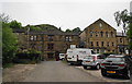
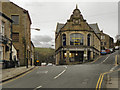
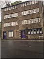
The Co-operative Hall and weavers' cottages
Taken from the official car park, with Knott Hill towering behind.
Image: © Bill Boaden
Taken: 28 Jun 2010
0.08 miles
2
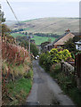
Knott Hill Lane, Delph
Heading towards the junction with Stoneswood Road. Delph village is at the bottom of this steep, narrow road.
Image: © michael ely
Taken: 2 Oct 2011
0.08 miles
4
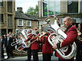
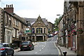
Delph Village, Saddleworth
The Saddleworth Brass Band Festival takes place on the Friday following the Whitsuntide bank holiday each year. Delph is one of several villages visited by competing bands from across the country. Photo taken at the junction of Stoneswood Road and Millgate outside the Players' Theatre.
Image: © michael ely
Taken: 4 Jun 2004
0.10 miles
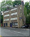
5
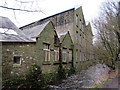
Millgate Arts Centre and Library
Delph has an arts centre based in what used to be the Co-op Store at the junction of Millgate and Stoneswood Road. It houses the Library, hosts the Saddleworth Players, Saddleworth Film Society and Saddleworth Chamber Concerts Society.
Image: © David Dixon
Taken: 3 Feb 2011
0.11 miles
6
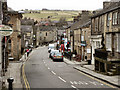
Delph: Millgate Arts Centre
The main road here is the A6052, leading to such places as Oldham, Ashton-under-Lyne, and Stockport; behind the photographer is the way to Rochdale or Halifax.
Image: © Dr Neil Clifton
Taken: 15 Jun 2015
0.11 miles
7
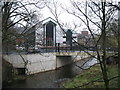
Saddleworth Business Park Delph
The new bridge over the river Tame provides easy access to this new business park in Delph
Image: © Paul Anderson
Taken: 18 Dec 2006
0.11 miles
9
Weaver's cottages, Delph
This pair of four-storey former weavers cottages stand at the junction of the A62 and A6052 (known locally as Delph station crossroads), in Delph, Greater Manchester, England.
Image: © Steven Haslington
Taken: 15 May 2012
0.12 miles
10
2-4 Oldham Road, Delph
A very good example of local C18th/19th houses with long rows of windows to light weavers' workshops inside. This one was built c1800. Grade II listed.
The side wall has an old metal Cadbury's sign.
Image: © Stephen Richards
Taken: 12 Jun 2016
0.12 miles