IMAGES TAKEN NEAR TO
Oldham Road, OLDHAM, OL2 8SP
Introduction
This page details the photographs taken nearby to Oldham Road, OL2 8SP by members of the Geograph project.
The Geograph project started in 2005 with the aim of publishing, organising and preserving representative images for every square kilometre of Great Britain, Ireland and the Isle of Man.

There are currently over 7.5m images from over14,400 individuals and you can help contribute to the project by visiting https://www.geograph.org.uk
Image Map
Images are licensed for reuse under creativecommons.org/licenses/by-sa/2.0
Notes
- Clicking on the map will re-center to the selected point.
- The higher the marker number, the further away the image location is from the centre of the postcode.
Image Listing (22 Images Found)
Images are licensed for reuse under creativecommons.org/licenses/by-sa/2.0
Image
Details
Distance
5
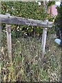
Twingates Community Nature Area Sign
Image: © thejackrustles
Taken: 18 Jul 2022
0.17 miles
6
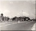
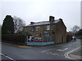
Big Lamp Roundabout
There used to a "Big Lamp" at this junction in Shaw. Although long gone it is still referred to as the "Big Lamp". Oldham Road here meets the A633 from Royton to Milnrow. Church Road on the other side leads towards Rochdale Road.
Image: © Gerald England
Taken: Unknown
0.17 miles
8
Cowlishaw Lane, Shaw #2
The lis as been painted out on the street sign.
Image]
Image: © Ian S
Taken: 11 Sep 2010
0.18 miles
9

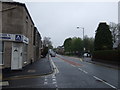
Shaw and Crompton Parish Boundary Plaque (2)
Located on the B6194, Oldham Road at Shaw Edge. The plaque in its geographic context can be seen here Image
Image: © michael ely
Taken: 6 Jan 2008
0.19 miles
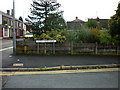
10
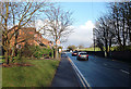
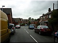
Shaw and Crompton Parish Boundary at Shaw Edge
The metal boundary plaque can be seen to the right of the traffic sign. View looking northeast along the B6194, Oldham Road. A close-up of the plaque can be seen here Image
Image: © michael ely
Taken: 6 Jan 2008
0.19 miles