IMAGES TAKEN NEAR TO
Black Clough, OLDHAM, OL2 8JY
Introduction
This page details the photographs taken nearby to Black Clough, OL2 8JY by members of the Geograph project.
The Geograph project started in 2005 with the aim of publishing, organising and preserving representative images for every square kilometre of Great Britain, Ireland and the Isle of Man.

There are currently over 7.5m images from over14,400 individuals and you can help contribute to the project by visiting https://www.geograph.org.uk
Image Map
Images are licensed for reuse under creativecommons.org/licenses/by-sa/2.0
Notes
- Clicking on the map will re-center to the selected point.
- The higher the marker number, the further away the image location is from the centre of the postcode.
Image Listing (21 Images Found)
Images are licensed for reuse under creativecommons.org/licenses/by-sa/2.0
Image
Details
Distance

3
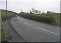
Grains Road Shaw
Here we have just left Shaw's built up area and the road narrows considerably to take on a more rural character. This is the point where the first steep hill chevron appears on the OS 1/50,000 map.
Image: © michael ely
Taken: 25 Feb 2010
0.15 miles
4
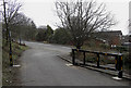
Barrier, Shore Edge, Buckstones Road
This new barrier was erected in March 2010. It will be locked from dusk to dawn in an attempt to prevent anti-social behaviour in the nearby Brushes Clough car park. From now on the druggies and the doggers will have to find their night time fun elsewhere. Keep your curtains closed.
Image: © michael ely
Taken: 1 Apr 2010
0.18 miles
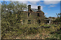
6
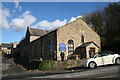
Shaw: Shore Edge Methodist church
Grand Stand cottages are seen in the background.
Image: © Dr Neil Clifton
Taken: 25 Feb 2016
0.19 miles
7
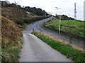
Dog Hill, Buckstones Road
Looking up the B6197, Buckstones Road as it climbs towards Grains Bar. The shot is taken from the very narrow lane that leads to Weeder Square.
Image: © michael ely
Taken: 2 Oct 2011
0.20 miles
8
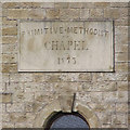
Primitive Methodist Chapel
The inscription stone above the entrance of Image
Image: © David Dixon
Taken: 13 May 2010
0.20 miles
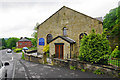
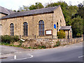
9
Shore Edge Methodist Church
The inscription above the door reads "Primitive Methodist Chapel 1873" (Image])
Image: © David Dixon
Taken: 13 May 2010
0.20 miles
10
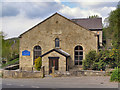
Shore Edge Methodist Church
Buckstones Road
Image: © David Dixon
Taken: 13 May 2010
0.20 miles