IMAGES TAKEN NEAR TO
Hannerton Road, OLDHAM, OL2 8HS
Introduction
This page details the photographs taken nearby to Hannerton Road, OL2 8HS by members of the Geograph project.
The Geograph project started in 2005 with the aim of publishing, organising and preserving representative images for every square kilometre of Great Britain, Ireland and the Isle of Man.

There are currently over 7.5m images from over14,400 individuals and you can help contribute to the project by visiting https://www.geograph.org.uk
Image Map
Images are licensed for reuse under creativecommons.org/licenses/by-sa/2.0
Notes
- Clicking on the map will re-center to the selected point.
- The higher the marker number, the further away the image location is from the centre of the postcode.
Image Listing (15 Images Found)
Images are licensed for reuse under creativecommons.org/licenses/by-sa/2.0
Image
Details
Distance
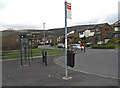
1
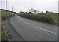
Grains Road Shaw
Here we have just left Shaw's built up area and the road narrows considerably to take on a more rural character. This is the point where the first steep hill chevron appears on the OS 1/50,000 map.
Image: © michael ely
Taken: 25 Feb 2010
0.12 miles

5
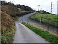
Dog Hill, Buckstones Road
Looking up the B6197, Buckstones Road as it climbs towards Grains Bar. The shot is taken from the very narrow lane that leads to Weeder Square.
Image: © michael ely
Taken: 2 Oct 2011
0.21 miles
6
Hillside Avenue, Shaw
Looking from the bus terminus near Crompton Buckstones Primary School.
Image: © michael ely
Taken: 31 Mar 2009
0.22 miles
7
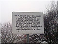
Greater Manchester Act 1981
Sign outlining the requirements of Section 163 of the Greater Manchester Act 1981, located in Shaw and Crompton, England.
I'm not sure why they needed to use the quotation marks.
Image: © Steven Haslington
Taken: 12 Jan 2011
0.23 miles
8
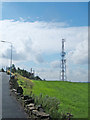
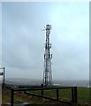
Dog Hill, Shaw
Ntl telecommunications mast just off Buckstones Road.
Image: © michael ely
Taken: 25 Aug 2006
0.24 miles
9
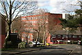
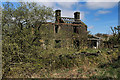
Shaw: Grains Road: old cotton mill
Shaw's legacy as a cotton town has not quite vanished. This is what was once the Dee Mill.
Image: © Dr Neil Clifton
Taken: 25 Feb 2016
0.24 miles
10
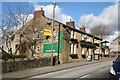
Shaw: Grains Road: The 'Morning Star'
Many pubs around here have closed, but some real gems remain, such as the 'Morning Star' on Grains Road, still serving an excellent pint of 'John Willie', (brewed locally at Middleton Junction by J W Lees).
Image: © Dr Neil Clifton
Taken: 25 Feb 2016
0.24 miles