IMAGES TAKEN NEAR TO
Woodford Avenue, OLDHAM, OL2 8HJ
Introduction
This page details the photographs taken nearby to Woodford Avenue, OL2 8HJ by members of the Geograph project.
The Geograph project started in 2005 with the aim of publishing, organising and preserving representative images for every square kilometre of Great Britain, Ireland and the Isle of Man.

There are currently over 7.5m images from over14,400 individuals and you can help contribute to the project by visiting https://www.geograph.org.uk
Image Map
Images are licensed for reuse under creativecommons.org/licenses/by-sa/2.0
Notes
- Clicking on the map will re-center to the selected point.
- The higher the marker number, the further away the image location is from the centre of the postcode.
Image Listing (10 Images Found)
Images are licensed for reuse under creativecommons.org/licenses/by-sa/2.0
Image
Details
Distance
1

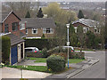
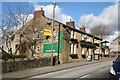
Delamere Avenue
A cul-de-sac of detached houses opposite Buckstones primary school.
Image: © michael ely
Taken: 25 Sep 2020
0.10 miles
2
Delamere Avenue, Shaw
A small cul-de-sac of 3 and 4 bedroom detached houses near Crompton Buckstones Primary School.
Image: © michael ely
Taken: 31 Mar 2009
0.11 miles
3
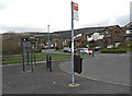
Hillside Avenue, Shaw
Looking from the bus terminus near Crompton Buckstones Primary School.
Image: © michael ely
Taken: 31 Mar 2009
0.12 miles
4
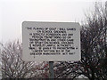
Greater Manchester Act 1981
Sign outlining the requirements of Section 163 of the Greater Manchester Act 1981, located in Shaw and Crompton, England.
I'm not sure why they needed to use the quotation marks.
Image: © Steven Haslington
Taken: 12 Jan 2011
0.13 miles
5
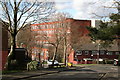
Shaw: Grains Road: old cotton mill
Shaw's legacy as a cotton town has not quite vanished. This is what was once the Dee Mill.
Image: © Dr Neil Clifton
Taken: 25 Feb 2016
0.14 miles
6
Linney Lane and Whitfield
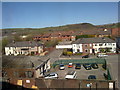
A view over Linney Lane in Shaw and Crompton, Greater Manchester. The wooded hill in the distance is Whitfield.
Image: © Steven Haslington
Taken: 21 Apr 2010
0.18 miles
7
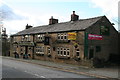
Shaw: Grains Road: The 'Morning Star'
Many pubs around here have closed, but some real gems remain, such as the 'Morning Star' on Grains Road, still serving an excellent pint of 'John Willie', (brewed locally at Middleton Junction by J W Lees).
Image: © Dr Neil Clifton
Taken: 25 Feb 2016
0.18 miles
8
Shaw: Grains Road: The 'Morning Star'
Image: © Dr Neil Clifton
Taken: 25 Feb 2016
0.19 miles
9
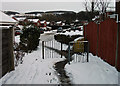
Cul-de-sac junction
This pedestrian access is between Arley Drive and Underwood Way, two cul-de-sacs. Looking towards Underwood Way.
Image: © michael ely
Taken: 3 Dec 2010
0.23 miles
10
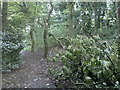
Damaged tree in Crompton Hall woods
Along this footpath in Crompton Hall woods, in Greater Manchester, lies part of a damaged tree, tore down by strong winds which struck the area a couple of nights earlier.
Image: © Steven Haslington
Taken: 28 Sep 2010
0.24 miles