IMAGES TAKEN NEAR TO
Dale Street, OLDHAM, OL2 8AU
Introduction
This page details the photographs taken nearby to Dale Street, OL2 8AU by members of the Geograph project.
The Geograph project started in 2005 with the aim of publishing, organising and preserving representative images for every square kilometre of Great Britain, Ireland and the Isle of Man.

There are currently over 7.5m images from over14,400 individuals and you can help contribute to the project by visiting https://www.geograph.org.uk
Image Map
Images are licensed for reuse under creativecommons.org/licenses/by-sa/2.0
Notes
- Clicking on the map will re-center to the selected point.
- The higher the marker number, the further away the image location is from the centre of the postcode.
Image Listing (118 Images Found)
Images are licensed for reuse under creativecommons.org/licenses/by-sa/2.0
Image
Details
Distance
1

Aldi, Shaw
On Greenfield Lane at the end of Eastway. This low cost supermarket now has Asda for competition about 200 yards away, but it appears to be thriving.
Image: © michael ely
Taken: 29 Jul 2010
0.03 miles
2
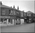
Norweb Showroom
The Norweb showroom on the corner of High Street and Refuge Street. The building and adjacent shops have since been demolished.
Image: © Christine Smedley
Taken: Unknown
0.04 miles
3
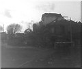
Shaw/Crompton Town Hall
Shaw & Crompton Urban District Council was based out of Shaw/Crompton Town Hall, which opened on 28 December 1894. Under the Local Government Act 1972, the town's Urban District status was abolished, and Shaw and Crompton has, since 1 April 1974, formed part of the Metropolitan Borough of Oldham, a local government district of the (then) metropolitan county of Greater Manchester. The Town Hall was neglected and part of the building fell down during a storm. It was subsequently demolished.
Image: © Gerald England
Taken: Unknown
0.04 miles
4
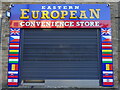
Shop on Market Street, Shaw
A fairly recent and colourful addition to the retail offer.
Image: © michael ely
Taken: 13 Oct 2020
0.05 miles

6

Crompton Health Centre
Situated on High Street, Shaw opposite the war memorial. It was built circa 1974. In recent years some doctors moved to a new health centre in nearby Royton and their Shaw patients were forced to travel further for their medical needs.
Image: © michael ely
Taken: 29 Jul 2010
0.05 miles
7
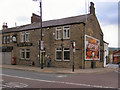
Duke of York
At the corner of Market Street and High Street, Shaw.
Image: © David Dixon
Taken: 11 May 2010
0.06 miles
8
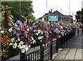
Floral display in Shaw
Situated on High Street opposite the health centre. The council is to be congratulated for making this gateway to the town centre very attractive. Looking towards the Crompton Way by-pass.
Image: © michael ely
Taken: 29 Jul 2010
0.06 miles
9
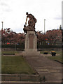
Crompton War Memorial and Memorial Gardens
Viewed from Westway, Shaw.
Image: © David Dixon
Taken: 11 May 2010
0.06 miles
10
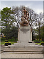
Crompton War Memorial
Set in the Memorial Gardens on High Street, Shaw.
Image: © David Dixon
Taken: 11 May 2010
0.06 miles