IMAGES TAKEN NEAR TO
Crompton Gate, OLDHAM, OL2 7WS
Introduction
This page details the photographs taken nearby to Crompton Gate, OL2 7WS by members of the Geograph project.
The Geograph project started in 2005 with the aim of publishing, organising and preserving representative images for every square kilometre of Great Britain, Ireland and the Isle of Man.

There are currently over 7.5m images from over14,400 individuals and you can help contribute to the project by visiting https://www.geograph.org.uk
Image Map
Images are licensed for reuse under creativecommons.org/licenses/by-sa/2.0
Notes
- Clicking on the map will re-center to the selected point.
- The higher the marker number, the further away the image location is from the centre of the postcode.
Image Listing (21 Images Found)
Images are licensed for reuse under creativecommons.org/licenses/by-sa/2.0
Image
Details
Distance
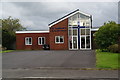
4

Post-mounted postbox
By the junction of Long Rushes and Trent Road, Higher Rushcroft, Shaw.
Image: © michael ely
Taken: 26 Jan 2013
0.18 miles
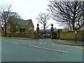
6

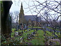
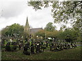
Shaw Cemetery
The chapel at Shaw and High Crompton Cemetery.
Image: © Roger May
Taken: 18 Nov 2005
0.19 miles
8
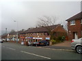
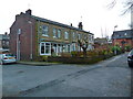
Row of shops on Duchess Street , Shaw
Across the road is a row of shops on Duchess Street, in the Rushcroft area of Shaw and Crompton, Greater Manchester.
Image: © Steven Haslington
Taken: 17 Mar 2011
0.19 miles
9
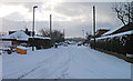
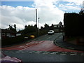
Hawkshead Road, Lower Rushcroft
After a heavy snowfall. Looking from the junction with Trent Road.
Image: © michael ely
Taken: 26 Jan 2013
0.20 miles