IMAGES TAKEN NEAR TO
Helmshore Way, OLDHAM, OL2 7UB
Introduction
This page details the photographs taken nearby to Helmshore Way, OL2 7UB by members of the Geograph project.
The Geograph project started in 2005 with the aim of publishing, organising and preserving representative images for every square kilometre of Great Britain, Ireland and the Isle of Man.

There are currently over 7.5m images from over14,400 individuals and you can help contribute to the project by visiting https://www.geograph.org.uk
Image Map
Images are licensed for reuse under creativecommons.org/licenses/by-sa/2.0
Notes
- Clicking on the map will re-center to the selected point.
- The higher the marker number, the further away the image location is from the centre of the postcode.
Image Listing (52 Images Found)
Images are licensed for reuse under creativecommons.org/licenses/by-sa/2.0
Image
Details
Distance
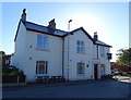
1

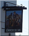
The Commercial Inn, Crompton
A Sam Smith's public house.
Image: © Ian S
Taken: 16 Jun 2013
0.05 miles
3
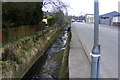
Pencil Brook, near Woodend, Shaw
This is where the culverted stream runs parallel with Duchess Street before flowing beneath Smallbrook Road.
Image: © michael ely
Taken: 14 Sep 2011
0.05 miles
4

The Commercial Inn, Crompton
A Sam Smith's public house.
Image: © Ian S
Taken: 16 Jun 2013
0.05 miles
5
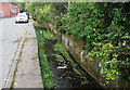
Pencil Brook
Looking upstream, alongside Duchess Street in High Crompton.
Image: © Paul Hogg
Taken: 22 Mar 2009
0.05 miles
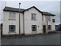
7
The Commercial Inn, Shaw
On Smallbrook Road.
Image: © JThomas
Taken: 18 Oct 2018
0.05 miles
8

The Commercial Inn, window detail, Crompton
A Sam Smith's public house.
Image: © Ian S
Taken: 16 Jun 2013
0.05 miles
9
The Commercial Inn, Crompton
A Sam Smith's public house.
Image: © Ian S
Taken: 16 Jun 2013
0.05 miles
10
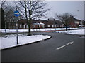
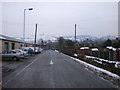
Road junction
Of Duchess Street and Cowie Street
Image: © Alexander P Kapp
Taken: 9 Feb 2009
0.05 miles