IMAGES TAKEN NEAR TO
Copley Street, OLDHAM, OL2 7TR
Introduction
This page details the photographs taken nearby to Copley Street, OL2 7TR by members of the Geograph project.
The Geograph project started in 2005 with the aim of publishing, organising and preserving representative images for every square kilometre of Great Britain, Ireland and the Isle of Man.

There are currently over 7.5m images from over14,400 individuals and you can help contribute to the project by visiting https://www.geograph.org.uk
Image Map
Images are licensed for reuse under creativecommons.org/licenses/by-sa/2.0
Notes
- Clicking on the map will re-center to the selected point.
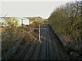
- The higher the marker number, the further away the image location is from the centre of the postcode.
Image Listing (46 Images Found)
Images are licensed for reuse under creativecommons.org/licenses/by-sa/2.0
Image
Details
Distance
2
Roadworks at Wrens Nest
White lines have recently appeared at the Milnrow Road/Smallbrook Road junction marking out what looks like a new road layout.
Image: © michael ely
Taken: 29 Jun 2010
0.05 miles
3
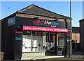
Shaw's new fitness centre
A new addition to the town's service sector. These premises have seen many uses over the years. I first remember them as Taylor's Bike Shop about forty years ago. They are situated at the corner of Milnrow Road and Chandos Street.
Image: © michael ely
Taken: 30 Jan 2010
0.05 miles
6
Metrolink Lines
The tramway system towards New Hey viewed from the Linney Lane bridge
Image: © Kevin Waterhouse
Taken: 9 Feb 2023
0.10 miles
7
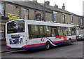
Bus on Milnrow Road, Shaw
At the bus stop outside the Weavers Answer pub.
Image: © michael ely
Taken: 2 Apr 2009
0.13 miles
8
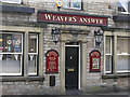
Weavers Answer
Pub on Milnrow Road, Shaw. It used to be called the Railway Hotel.
Image: © michael ely
Taken: 2 Apr 2009
0.14 miles
9
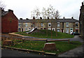
Children's play area, Shaw
Situated between Duckworth Street and Gordon Street (off Oak Street). The terraced houses in the background are on Gordon Street.
Image: © michael ely
Taken: 5 Nov 2010
0.14 miles
10
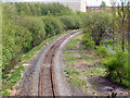
Oldham Loop Line
Looking towards Shaw along the (currently closed) "Oldham Loop Line". Viewed from Milnrow Road.
Image: © David Dixon
Taken: 13 May 2010
0.18 miles