IMAGES TAKEN NEAR TO
Lyon Street, OLDHAM, OL2 7RU
Introduction
This page details the photographs taken nearby to Lyon Street, OL2 7RU by members of the Geograph project.
The Geograph project started in 2005 with the aim of publishing, organising and preserving representative images for every square kilometre of Great Britain, Ireland and the Isle of Man.

There are currently over 7.5m images from over14,400 individuals and you can help contribute to the project by visiting https://www.geograph.org.uk
Image Map
Images are licensed for reuse under creativecommons.org/licenses/by-sa/2.0
Notes
- Clicking on the map will re-center to the selected point.
- The higher the marker number, the further away the image location is from the centre of the postcode.
Image Listing (92 Images Found)
Images are licensed for reuse under creativecommons.org/licenses/by-sa/2.0
Image
Details
Distance
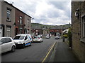
7
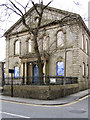
Shaw St Pauls
St Paul's Church, Rochdale Road, Shaw.
Image: © David Dixon
Taken: 11 May 2010
0.06 miles
8
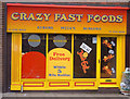
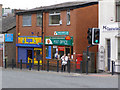
Crazy Fast Foods
I'm sure the doctors would agree. You can now order your kebabs, burgers and pizzas on-line. But presumably you've got to get off your backside when they ring the door bell. Situated on Milnrow Road, Shaw, near the junction with Beal Lane.
Image: © michael ely
Taken: 23 Oct 2006
0.07 miles
10
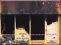
Some like it hot
In the early hours of 14 December 2009 this fast food shop was allegedly torched. It was part of the Greenway retail development on Milnrow Road. Neighbouring shops were also affected and had to close. To see the shop front three years earlier click http://www.geograph.org.uk/photo/265537
Image: © michael ely
Taken: 14 Dec 2009
0.07 miles